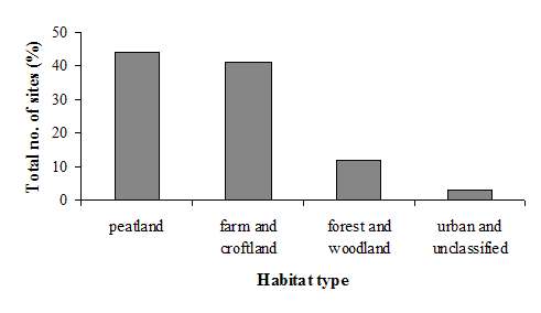
Figure 4: Percentage number of sites in each habitat type category.
| N E W S F E E D S >>> |
NATURE AND ENVIRONMENT
Highland Bio-diversity
|
CAITHNESS BIODIVERSITY
GROUP The Distribution of the Water
Vole in Caithness |
|
Introduction & Method |
Results Continued
Figure 4: Percentage number of sites in each habitat type
category.
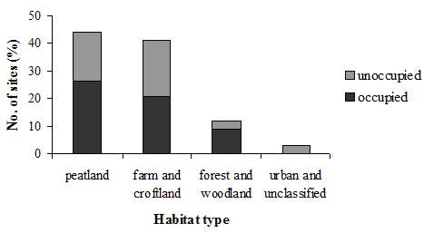
Figure 5: Percentage number of sites in each habitat type
category,
showing the division between occupied and unoccupied sites.
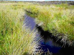
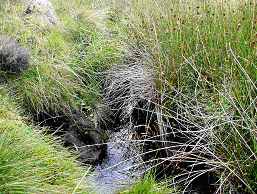
Figure 6: Example of suitable habitat at Allt na
Craoibhe, Latheronwheel Estate.
Table 2: Examples of plant species found in (a) suitable habitat and (b) unsuitable habitat.
(a)
|
Habitat/ |
Suitable |
|
plant group |
‘Typical’ |
| Rushes | soft rush (Juncus effusus) |
| conglomerated rush (J. conglomeratus) | |
| Grasses | tufted hair-grass (Deschampsia caespitosa) |
| Yorkshire fog (Holcus lanatus) | |
| Purple Moor-grass (Molinia caerulea) | |
| Reeds | Reed sweet-grass (Glyceria maxima) |
| Sedges | Bottle sedge (Carex rostrata) |
| Common sedge (C. migra) | |
|
‘Poor’ |
|
| Water plants | watercress (Nasturtium officinale) |
| Wetland/ edge plants | cuckoo flower (Caramine amara) |
| meadowsweet (Filipendula ulmaria) | |
| watermint (Mentha aquatica) | |
| brooklime (Veronica beccabunga) |
(b)
|
Unsuitable |
|
|
Plant group |
Heather |
| Horsetail | |
| Ferns | |
| Gorse |
| Table 3: Habitat type and suitability at each (a) occupied and (b) unoccupied site. Occupied sites also have an extra classification of occupancy level. Where there is more than one habitat type listed, the first in the list represents the majority of the habitat. |
(a) Occupied Sites
| Site name | Habitat type | Habitat suitability | Signs |
| Allt na Craoibhe | peatland | typical | high |
| Biel of Duncansby | peatland | typical | medium |
| Munsary and Ballharn | peatland | typical | medium |
| Allt nam Beist | peatland | typical | medium |
| Loch Beg and Lochan Dubh | peatland | typical | medium |
| Allt Caol | peatland | typical | medium |
| Loop Burn and Burn of Aultachlevan | peatland | typical | medium |
| Loch Hollistan | peatland | typical | low |
| Gill Burn | peatland | poor | medium |
| Burn of Tacher | farm and
croftland,
peatland |
typical | high |
| Little River | farm and croftland | typical | low |
| Burn of Latheronwheel | farm and croftland | typical | low |
| Thrumster | farm and croftland | poor | medium |
| Lower River Forss | farm and croftland | poor | low |
| Burn of Rattar | farm and croftland | poor | low |
| Achsinegar | farm and croftland | poor | low |
| Newtonhill Community Woodland | forest and woodland | typical | medium |
| Achairn Forest | forest and woodland | typical | medium |
| Loch Saorach and Thormaid | forest and woodland | typical | medium |
| (b) Unoccupied Sites | |||
| Site name | Habitat type | Habitat suitability | |
| Allt Chaiteag | peatland | suitable | |
| Allt nam Sealbhag | peatland | suitable | |
| Torran Water | peatland | suitable | |
| Loch Garbh | peatland | suitable | |
| Sinigoe Burn | peatland | suitable | |
| Dunbeath Water | peatland | unsuitable | |
| North Calder | farm and croftland | suitable | |
| Strath Burn | farm and croftland | suitable | |
| Midsand Burn | farm and croftland | unsuitable | |
| Broubster Leans | farm and croftland | unsuitable | |
| Wick River | farm and croftland | unsuitable | |
| Loch Scarmclate | farm and croftland | unsuitable | |
| Wolf Burn and Scrabster Loch Burn | farm and croftland, urban and unclassified | suitable | |
| Rumster Forest | forest and woodland | unsuitable | |
| Lower River Thurso | urban and unclassified | unsuitable |
(a)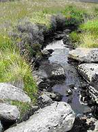 (b)
(b)
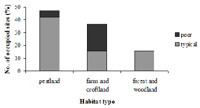
Figure 8: Percentage number of occupied sites with
‘typical’ and ‘poor’ habitat in each habitat type.
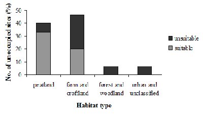
Figure 9: Percentage number of unoccupied sites
with suitable and unsuitable habitat in each habitat type.
© Crown Copyright. The Highland Council
2005. 100023369
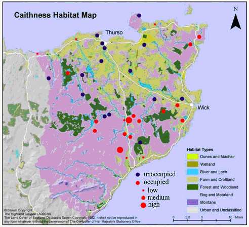
Figure 10: Map of Caithness showing the surveyed sites that are occupied and
unoccupied.
Occupied sites also show level of occupancy.