© Crown Copyright. The Highland Council 2005. 100023369
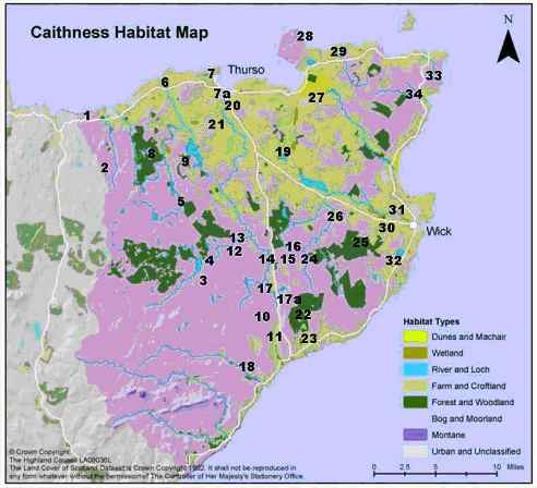
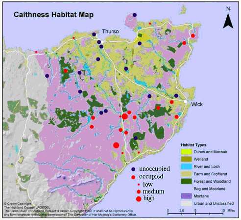
Figure 3: Map of Caithness showing the location of all sites surveyed. The numbers relate to those in Table 1.
| N E W S F E E D S >>> |
NATURE AND ENVIRONMENT
Highland Bio-diversity
|
CAITHNESS BIODIVERSITY
GROUP The Distribution of the Water
Vole in Caithness |
|
Introduction & Method Results Page One Results Continued Discussion Future Work - Acknowledgements - References |
|
Results A total of 34 sites were surveyed, 19 (56%) of which were found to be occupied with water voles and the remaining 15 (44%) unoccupied. Occupied sites were found in 11 (64.7%) of the 17 10 km squares chosen for surveying. Table 1 shows the location of all survey sites along with the 10 km square that each survey site was located in and the extent of area surveyed at each site. Figure 3 shows the locations of all surveyed sites, as numbered in Table 1. The survey sites were classified, in terms of habitat type, using the Caithness Habitat Map from the Caithness Biodiversity Action Plan (February 2003). The surveyed sites covered 4 main habitat types, bog and moorland (from now on referred to as peatland), farm and croftland, forest and woodland and urban and unclassified. In total, 44.1% (15/34) of the surveyed sites were peatland, 41.2% (14/34) were farm and croftland, 11.8% (4/34) were forest and woodland and 2.9% (1/34) were urban and unclassified (Figures 4 and 5). Of the occupied sites, 47.4% (9/19) were peatland, 36.8% (7/19) were farm and croftland and 15.8% (3/19) were forest and woodland. Forty percent (6/15) of unoccupied sites were in peatland, 46.7% (7/15) were farm and croftland, 6.7% (1/15) were forest and woodland and 6.7% (1/15) were urban and unclassified. In one case, a site was initially determined as unoccupied but was re-surveyed 3 weeks later and was found then to be occupied. This occurred at Loch Hollistan which has been classified as occupied in the analysis. All occupied sites had a defined flow of water, such as a burn or ditch, except Newtonhill Community Woodland. Here, signs of occupancy were found in a marshy area with standing water. Bank vegetation was varied. In general, peatland areas had a high level of vegetation cover which was commonly a mix of tall grasses, sedges and rushes, for example Allt na Craoibhe (Figure 6). In areas of farm and croftland, where grazing had been allowed up to the water’s edge, vegetation was short with discrete tussocks of rushes or sedges (as found at the Little River, Tacher). In other areas of farm and croftland, grazing was not permitted near the water because of fencing. This had led to the area becoming densely overgrown, with plants other than grasses and rushes tending to dominate. An example of this is the area surveyed on Thrumster Estate. In forest and woodland areas, suitable habitat and positive occupancy were recorded in open areas where growth of ground vegetation was not restricted by tree cover, for example in Achairn forest. There was no positive occupancy in areas categorised as urban and unclassified. For a list of example plant species found in suitable and unsuitable habitat see Table 2. This variety of vegetation found at
occupied sites led to a further classification which divided suitable
habitat. ‘Typical’ habitat had good vegetation cover of grasses, sedges
and rushes, with few shrubby plants e.g. Allt na Craoibhe or Achairn
Forest. ‘Poor’ habitat had adequate vegetation cover which was generally
tall, but overgrown and dominated by plants such as meadow sweet, thistles
and nettles. Grasses and rushes were present but commonly only near to the
water’s edges. A higher proportion of stones/rocks in the water or
intermittently on the banks was also characteristic of ‘poor’ habitat e.g.
Thrumster estate or Achsinegar (Table 3). It should, however, also be
noted that in positively occupied sites, the habitat was generally not
continuously suitable across the complete length of the survey. Occupied sites were 73.7% (14/19) typical and 26.3% (5/19) poor habitat. Suitable habitat was also found at 53.3% (8/15) of unoccupied sites. At the remaining 46.8% (7/15) of unoccupied sites, habitat was unsuitable (Figures 8 and 9). Estimates of abundance have, in the past, been predicted using a correlation between number of latrines and total population of adults and juveniles (3); however, this correlation may not be valid in all habitats, particularly if water vole populations are small and fragmented (3). Estimates of abundance have therefore not been attempted but instead each occupied site was assigned a crude level of occupancy according to the quantity and distribution of signs that were found. There were 3 categories: low, medium and high. Sites classified as having low occupancy were those where only a few, isolated signs were found, for example a couple of droppings up to 3 latrines. Medium occupancy was used to describe sites where signs were numerous but had a patchy distribution. High occupancy was determined by a continuous stretch of signs over a distance of at least 100m. The majority (57.9%) of occupied sites had a medium level of occupancy. 31.6% of occupied sites had a low level of occupancy and 10.5% were highly occupied (Figure 10). |
Table 1:
Survey site locations, showing the 10km square each site was located in,
the extent of area surveyed, in grid squares, and the result of the survey.
| Survey site location | 10km square | Extent of area surveyed (grid squares) | Positive occupancy? | |
| 1 | Loch Hollistan | NC 9060 | NC 9264 | yes |
| 2 | Loch Garbh | NC 9060 | NC 9360, 9361, 9362, 9462 | no |
| 3 | Allt nam Beist | ND 0040 | ND 0842, 0843, 0844, 0943 | yes |
| 4 | Loch Beg and Lochan Dubh | ND 0040 | ND 0896, 0946 | yes |
| 5 | Torran Water | ND 0050 | ND 0452, 0552, 0553, 0554 | no |
| 6 | Lower River Forss | ND 0060 | ND 0269, 0367, 0368, 0369, 0466, 0467 | yes |
| 7 | Wolf Burn
and Scrabster
Loch Burn |
ND 0060 | ND 0870, 0968, 0970, 1068,1069, | no |
| 8 | Loch Saorach and Thormaid | ND 0060 | ND 0159, 0060, 0160, 0161, 0260 | yes |
| 9 | Broubster Leans | ND 0060 | ND 0360, 0460 | no |
| 10 | Allt na Craoibhe | ND 1030 | ND 1637, 1737 | yes |
| 11 | Burn of Latheronwheel | ND 1030 | ND 1736 | yes |
| 12 | Allt Chaiteag | ND 1040 | ND 1145, 1146, 1147, 1244, 1245 | no |
| 13 | Allt nam Sealbhag | ND 1040 | ND 1245, 1246, 1247 | no |
| 14 | Little River | ND 1040 | ND 1746, 1747 | yes |
| 15 | Burn of Tacher | ND 1040 | ND 1746, 1846 | yes |
| 16 | Allt Caol | ND 1040 | ND 1947 | yes |
| 17 | Loop Burn and Burn of Aultachlevan | ND 1040 | ND 1642, 1741, 1742, | yes |
| 18 | Dunbeath Water | ND 1040 | ND 1341, 1342, 1429, 1430, 1431, 1529, 1530, 1629, | no |
| 19 | Loch Scarmclate | ND 1050 & 1060 | ND 1859 | no |
| 20 | Lower River Thurso | ND 1060 | ND 1167, 1168 | no |
| 21 | North Calder | ND 1060 | ND 0961, 1061, 1161 | no |
| 22 | Rumster Forest | ND 2030 | ND 2036, 2037, 2038, 2137, 2139, 2140 | no |
| 23 | Achsinegar | ND 2030 | ND 2235 | yes |
| 24 | Munsary and Ballharn | ND 2040 | ND 2144, 2145, 2146, 2244, 2245, 2246 | yes |
| 25 | Achairn Forest | ND 2040 | ND 2847, 2848, 2849, 2947 | yes |
| 26 | Strath Burn | ND 2050 | ND 2453, 2552, 2454 | no |
| 27 | Midsand Burn | ND 2060 | ND 2168, 2268, 2368, 2369 | no |
| 28 | Sinigoe Burn | ND 2070 | ND 2174, 2175 | no |
| 29 | Burn of Rattar | ND 2070 | ND 2573 | yes |
| 30 | Newtonhill Community Woodland | ND 3040 | ND 3449 | yes |
| 31 | Wick River | ND 3050 | ND 3151, 3152, 3251, 3252, 3352, 3452 | no |
| 32 | Thrumster Estate | ND 3040 | ND 3145, 3244, 3245, 3345, 3346 | yes |
| 33 | Biel of Duncansby | ND 3070 | ND 3870, 3871 | yes |
| 34 | Gill Burn | ND 3090 | ND 3567, 3667 | yes |
© Crown Copyright. The Highland Council 2005.
100023369
Figure 3: Map of Caithness showing the location of
all sites surveyed. The numbers relate to those in Table 1.
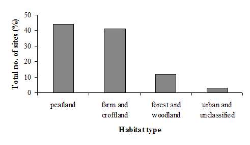
Figure 4: Percentage number of sites in each habitat type
category.
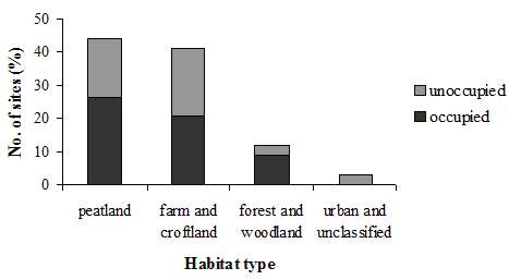
Figure 5: Percentage number of sites in each habitat type
category,
showing the division between occupied and unoccupied sites.
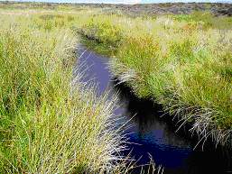
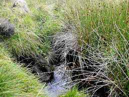
Figure 6: Example of suitable habitat at Allt na
Craoibhe, Latheronwheel Estate.
Table 2: Examples of plant species found in (a) suitable habitat and (b) unsuitable habitat.
(a)
|
Habitat/ |
Suitable |
|
plant group |
‘Typical’ |
| Rushes | soft rush (Juncus effusus) |
| conglomerated rush (J. conglomeratus) | |
| Grasses | tufted hair-grass (Deschampsia caespitosa) |
| Yorkshire fog (Holcus lanatus) | |
| Purple Moor-grass (Molinia caerulea) | |
| Reeds | Reed sweet-grass (Glyceria maxima) |
| Sedges | Bottle sedge (Carex rostrata) |
| Common sedge (C. migra) | |
|
‘Poor’ |
|
| Water plants | watercress (Nasturtium officinale) |
| Wetland/ edge plants | cuckoo flower (Caramine amara) |
| meadowsweet (Filipendula ulmaria) | |
| watermint (Mentha aquatica) | |
| brooklime (Veronica beccabunga) |
(b)
|
Unsuitable |
|
|
Plant group |
Heather |
| Horsetail | |
| Ferns | |
| Gorse |
| Table 3: Habitat type and suitability at each (a) occupied and (b) unoccupied site. Occupied sites also have an extra classification of occupancy level. Where there is more than one habitat type listed, the first in the list represents the majority of the habitat. |
(a) Occupied Sites
| Site name | Habitat type | Habitat suitability | Signs |
| Allt na Craoibhe | peatland | typical | high |
| Biel of Duncansby | peatland | typical | medium |
| Munsary and Ballharn | peatland | typical | medium |
| Allt nam Beist | peatland | typical | medium |
| Loch Beg and Lochan Dubh | peatland | typical | medium |
| Allt Caol | peatland | typical | medium |
| Loop Burn and Burn of Aultachlevan | peatland | typical | medium |
| Loch Hollistan | peatland | typical | low |
| Gill Burn | peatland | poor | medium |
| Burn of Tacher | farm and
croftland,
peatland |
typical | high |
| Little River | farm and croftland | typical | low |
| Burn of Latheronwheel | farm and croftland | typical | low |
| Thrumster | farm and croftland | poor | medium |
| Lower River Forss | farm and croftland | poor | low |
| Burn of Rattar | farm and croftland | poor | low |
| Achsinegar | farm and croftland | poor | low |
| Newtonhill Community Woodland | forest and woodland | typical | medium |
| Achairn Forest | forest and woodland | typical | medium |
| Loch Saorach and Thormaid | forest and woodland | typical | medium |
| (b) Unoccupied Sites | |||
| Site name | Habitat type | Habitat suitability | |
| Allt Chaiteag | peatland | suitable | |
| Allt nam Sealbhag | peatland | suitable | |
| Torran Water | peatland | suitable | |
| Loch Garbh | peatland | suitable | |
| Sinigoe Burn | peatland | suitable | |
| Dunbeath Water | peatland | unsuitable | |
| North Calder | farm and croftland | suitable | |
| Strath Burn | farm and croftland | suitable | |
| Midsand Burn | farm and croftland | unsuitable | |
| Broubster Leans | farm and croftland | unsuitable | |
| Wick River | farm and croftland | unsuitable | |
| Loch Scarmclate | farm and croftland | unsuitable | |
| Wolf Burn and Scrabster Loch Burn | farm and croftland, urban and unclassified | suitable | |
| Rumster Forest | forest and woodland | unsuitable | |
| Lower River Thurso | urban and unclassified | unsuitable |
(a)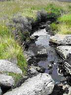 (b)
(b)
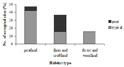
Figure 8: Percentage number of occupied sites with
‘typical’ and ‘poor’ habitat in each habitat type.
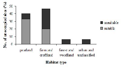
Figure 9: Percentage number of unoccupied sites
with suitable and unsuitable habitat in each habitat type.
© Crown Copyright. The Highland Council
2005. 100023369
Figure 10: Map of Caithness showing the surveyed sites that are occupied and
unoccupied.
Occupied sites also show level of occupancy.