|
The Strategic Assessment Study will be in several parts, viz: -
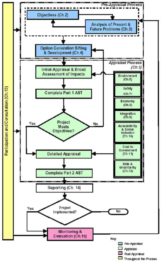
Throughout the study, there will be an iterative and interactive process, with the Market Research and Initial Market Assessment reacting with the Timetable Modelling and Simulation to produce the best fit. In turn the Timetable Modelling and Simulation will interact with the Engineering and Environmental Assessments to determine the best infrastructure requirement. The Value Engineering will drive out the costs and interact with the others to produce the most beneficial cost effective scheme. This will feed back into the Passenger Demand and Economic Study to provide an answer on how the scheme will meet the needs of the population of the Highlands and Islands and provide an analysis of the costs and benefits. The optioneering will be in accordance with STAG Part One appraisal guidelines.
4.1 Market Research The study would build on work already done by the Highlands and Islands Enterprise (HIE). [Commuting Rail Services in the Inverness Area � Carl Bro March 2003, The Case for Rail in the Highlands and Islands � Steer Davies Gleave Final Report March 2004] Corus assumes that the HIE would be willing to make available the base data from these studies. The studies are however conducted on the basis of actual train travel. As the services Corus are proposing are new, with new infrastructure, Corus proposes to conduct Market Research to determine the propensity to travel in the Highlands. The demand forecast could be improved by validating certain variables through a modest programme of Market Research. We propose 100 structured, �in-home� interviews, each lasting about 20 minutes. The questionnaire would be devised in order to probe existing travel patterns, destinations, attitudes to modes, journey purpose, etc. Professional market researchers would be used, working in the evenings and at weekends in order to gain a representative sample of the population. Quotas would be set based on age, gender, house type and location. A separate report of findings would be compiled to feed into the main study. This element of the proposal would be sub-contracted to a specialist local Market Research company with previous experience of transport studies 4.2 Initial Market Assessment Corus recognise the importance of a market focus for modern railway enhancement schemes and propose to undertake an initial market assessment on the Thurso and Wick to Inverness corridor. The results of the assessment will be used to inform the operational model so that the service offer is designed to best meet the needs of the market. Method Data Sources 4.3 Operations Modelling Corus will construct a Base Model of the existing railway infrastructure and timetable. This would be done with a RailSys� simulation of the line from Inverness to Thurso and Wick. The simulation would model the infrastructure and the traction characteristics of the trains. This will be used as a reference point for the subsequent Case Studies. The Base Model, will in essence be the �Do Nothing� option in the STAG assessment. Next Corus will create Case Study One. Corus will define an alignment (See Engineering Assessment) for the Tain � Golspie Link and the Georgemas Chord. This will be modelled to demonstrate the impact of the proposal on the viability of the whole route.
The full route will be modelled to identify the infrastructure constraints limiting train performance and to see where reasonable improvements could be made to bring down the journey times to compete more effectively with road transport. Case Study One will then model an all stations timetable similar to the Base Model, but with all services diverted over the new infrastructure. This will provide a direct comparison with the Base Model and can be compared with Case Study Two in the evaluation. Case Study Two will take the data from the Market Demand and Economic Evaluation already conducted and produce a timetable to reflect that demand. The timetable will include the concept of two services, a local commuting service over the southern section of the route and an express service designed to attract additional traffic originating in Sutherland, Caithness and Orkney. The integration of tourist charter services and freight traffic will also be considered.
Data requirements; a pre-requisite of the study is participation of various stakeholders, including Network Rail and First Group (Scotrail). The study will need: -
4.4 Passenger Demand and Economic Study Following on from the operations modelling stage options will be selected and Corus will provide a passenger demand and economic benefits forecast for inclusion in any Outline Business Case. Method PDFH and MOIRA focus on incremental forecasting procedures, for example changes to existing levels of demand due to changes in key factors such as journey times, service frequency, reliability, service quality, fares and wider economic changes. An incremental approach has limited application to the Rail Link proposal rather we would concentrate on forecasting absolute numbers of rail trips. This is because we expect few similarities between existing rail trips on the route via Lairg and the likely new demand via the Rail Link. There are a number of approaches that can be taken to forecasting absolute demand for new or re-opened rail services. A simple market research approach can be prone to overstatement, for example in response to questions like �Would you use a new rail service?� respondents often say �Yes� because they would like to have a positive influence on the decision - they believe the proposal is a �good thing�. More complex stated preference market research techniques reduce the problem of bias described above but are very expensive and often it is difficult to determine the right mathematical logic to convert research findings into a numerate forecast. Gravity modelling (i.e. analysis by the �weight� of population) is inadequate on its own because other demand variables are missed. Generalised cost modelling is often used for new rail or station studies, but requires considerable amounts of high quality data to be effective. This approach risks overlooking local conditions and usually relies on logit model formulation that may give the impression, to a non-technical audience, of a �black-box� process, which can undermine confidence in the forecast. We propose to build a simple bespoke demand forecasting process for this project based around the principles of trip rate modelling. This gives those who need to make decisions arising out of any study findings the transparency of process that will enable them to form their own judgement on the confidence range that we will recommend. One of the weaknesses of trip rate analysis is the failure of pick up variations in trip types. We propose to overcome this by extending the analysis to include trip distances and some element of gravity modelling. The use of modal shares, ticket sales data from comparable flows and stations, census data and demographic information will enable us to develop a trip rate based forecast that will be both quantitative and as accurate as possible with the available data. A key element of our approach to
this study will be to draw in qualitative information gained from many
sources including consultation, desk research and reference to earlier
HIE commissioned studies. This will ensure local issues are fully
addressed in the resulting forecast. � Public Transport co-ordination We believe that our proposed approach will achieve the right balance between quantitative inputs and qualitative inputs to produce a robust forecast. Output from the demand
forecasting model will be used to evaluate economic benefits in relation
to: Data Sources We will also use data from these studies with other desk research and consultation to assess local conditions and the potential benefits of the Rail Link, contribution to the local economy of the area, employment, in-bound tourism, and access to training or local services. Assessment will follow STAG principles. 4.5 Engineering Appraisal A desk study of the British Rail
1985 proposals for the Tain � Golspie Rail Link and an alternative Corus
alignment for the Tain � Golspie Rail Link will be made. The following
information will be obtained and reviewed, where available:
The study will define an
alternative Corus alignment at Dornoch and Loch Fleet. A Corus alignment
will also be defined for a new west to north chord line at Georgemas
Junction with a new station at Halkirk. The extent of earthworks and structures required for the 1985 BR Tain � Golspie Rail Link and the Corus alignments for the Tain � Golspie Rail Link and the Georgemas Chord will be identified, by consideration of the available information. A desk based Geo-Technical investigation will be carried out, reviewing all existing information, commenting on potential problems associated with the geology of the selected route(s) and suggested engineering solutions. Limited site visits and inspections will be made to confirm details. Outline sketches will be produced for each of the significant structures in sufficient detail to enable outline costing. Methods of construction will be reviewed and temporary land take requirements identified together with access for maintenance purposes. The major structures will include the Dornoch Firth and Loch Fleet crossings, other bridges, retaining structures and tunnels.
Alignment drawings will be
produced for the Corus alignments for the Tain � Golspie Rail Link and
the Georgemas Chord with the routes superimposed upon Ordnance Survey
background mapping, in a similar style to the 1985 Provisional Order
Drawings. 4.6 Environmental Assessment Development of the line will provide a sustainable transport option for this part of Scotland, and will lead to positive long-term environmental benefits (e.g. reduction of traffic emissions). At the same time the actual implementation of the scheme will give rise to negative (although more localised) impacts � such as impacts on the landscape, on ecology and on nearby sensitive receptors (e.g. from increases in noise). Given this it is essential that a high-level appraisal be undertaken of the scheme options in order to fully understand the associated environmental implications.
It is therefore proposed to undertake the following during the feasibility / optioneering stage:
4.7 Value Management Engineering Corus believes that the cost of railway construction has escalated out of proportion to the needs of the client and end customer. Value management and engineering techniques will be used to define appropriate options and specifications. The horizontal and vertical alignments of whole Far North Line would be appraised to determine higher maximum permissible line speeds. Where possible, Corus would want to achieve consistent 90 mph running. Where available, engineering maintenance records would be appraised to determine the effect on the infrastructure of higher speeds. The results of this appraisal would be input into the operations model, to determine which improvements would deliver time benefits and at what cost. Similarly with the new railway alignments, the improvements would be driven by the marketing and service needs and the specification adjusted accordingly. There is a need to produce low
cost methods of operation for the Far North Line. The simplest signalling would be
to use radio despatching using CANAC�s Computer Aided Manual Block
System (CAMBS) from North America, similar to the Ravenglas and Eskdale
Line, but this is unlikely to meet with regulatory approval. Corus� initial assessment for signalling for the junctions is that it may be necessary to use a form of electronic interlocking with Programmable Logic Controllers (PLC) such as the GE Harmon and Westrace (Westinghouse) systems and to produce costs for that. Corus will propose cost effective options, adequate for the traffic to be carried. The whole life costs of the Far North Line schemes would be examined, including asset life and renewals. This would include the engineering maintenance and associated possession requirements for the steady state operation of the railway and how this would affect the day to day train operations on the line. Through Value Engineering Corus is able to offer an innovative, but realistic appraisal of the Far North Line including the Tain - Golspie and Halkirk schemes. 4.8 Final Report
A report will be prepared at the end of the study,
which will give definitive answers to the issues.
The report will comply with STAG guidelines with
Appraisal Summary Tables.
The findings of the market research into the propensity to travel will be commented on, with the implications for the total rail market. The Initial Market Assessment will show the level of passenger demand by origin, destination and time. The Operations Modelling will show how the service plan has been developed to reflect both the Initial Market Assessment and also to define the infrastructure requirements that best meet that assessment. The Engineering Assessment will report on the infrastructure required to deliver the timetable and give an estimate of the costs for the preferred route. The Engineering Assessment will also report on the issues over bridging the Dornoch Firth and Loch Fleet. The Environmental Assessment will report on the advisability of the preferred route and provide a risk matrix for the environmental issues encountered and an Environmental Features Map. The cost issues will be reported on in the Value Management and Engineering assessment, with a cost-effective specification for infrastructure improvement and the service level proposed. Finally the proposed service level will be reported on from a passenger demand perspective. The economic
benefits of that railway service will be evaluated and reported on. The report will give definitive answers on the feasibility and viability of the Tain � Golspie Rail Link and the Georgemas Chord. These assessments will set out how the improvements could be taken forward to STAG Part Two appraisal and to the Parliamentary Bill Stage |
|
| Forward To Project Team | |
