| Caithness.Org | Community | Business | Entertainment | Caithness... | Tourist Info | Site Map |
• Advertising • Chat Room • Contact Us • Kids Links • Links • Messageboard • News - Local & Scottish • News - UK & News Links • About / Contact Us • Submissions |
• Bookshop • Business Index & News • Jobs • Property For Sale • Property For Rent • Shop • Sutherland Business Index |
• Fishing • Fun Stuff • George, The Saga • Horses • Local Galas • Music • Pub Guide • Sport Index • What's On In Caithness |
• General Information • B & Bs • Backpackers • Caravan & Camping • Ferries • Getting Here • Holiday Letting • Hotels • Orkney • Pentland Firth • Sutherland • Taxis |
| N E W S F E E D S >>> |
|
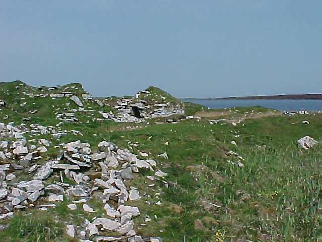
Why not step back in time to walk around the many sites on the Yarrows Trail. The ground is fairly rough but quite accessible for the relatively fit walker. Much of the walk is from the shore of a small loch now a reservoir uphill and downhill following a circular route if you attempt the whole walk. Some parts are relatively steep and the ground can be very boggy. Some work has been done to assist access in the wettest areas to allow crossing. Come with us now for a
brief trip to a period beginning in the Stone Age or Neolithic Period
and spanning about 5000 years between 4000 � 2000 BC. The sites
at Yarrows have had human occupation much of the 5000 years beginning in
the Stone Age with the building of the chambered burial cairns (sites
2,3,6,7 & 8). These huge cairns dominate the landscape today
just as they were meant to do when they were first built. Burial
places for whole communities, they remained in use for well over 1000
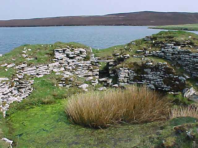
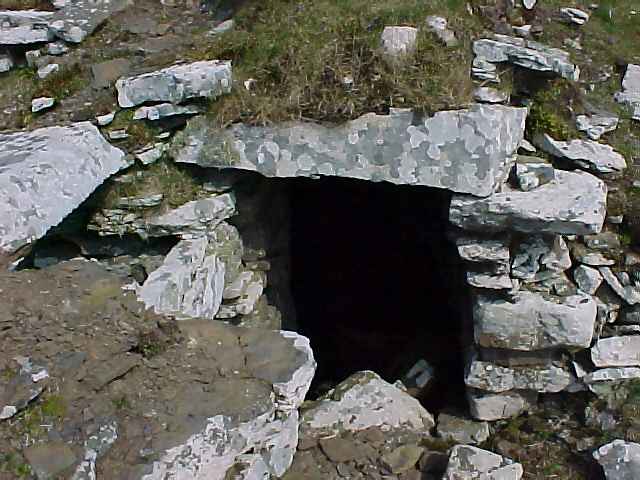
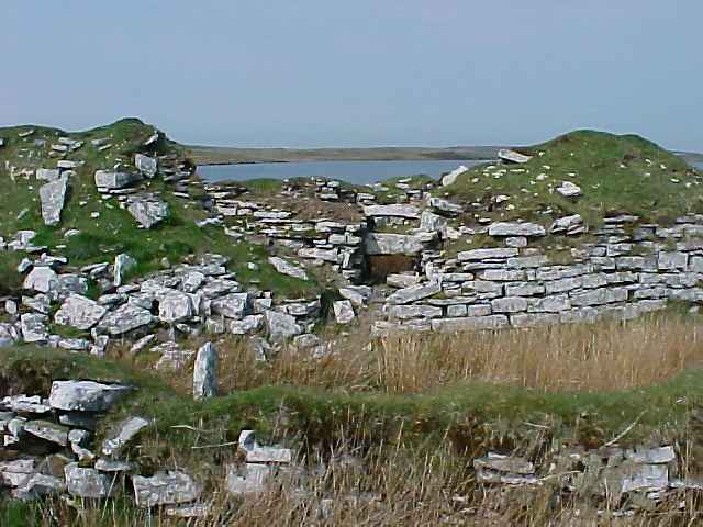
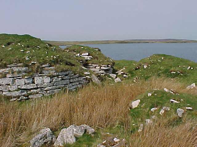
years, with successive burials taking place over that time. The large number of cairns at Yarrows may be due to this being an unusually hilly part of Caithness, and they may have served several communities from a wide area round about. Each consists of a burial chamber built of massive slabs and dry-stone walling underneath a massive covering cairn. The chambers were entered through narrow passages leading from the cairn edge and would have been blocked up between burials. At yarrows, the chambers are in three parts, separated by huge slabs set upright at right angles to the walls. Three are long cairns, with projections at the end known as "horns", while the other two are circular in shape. Several have modern marker cairns built on top of them. Please do not add to these as it damages the monuments. The Stone Age settlers were farmers, but as their houses were probably built of wood, no trace survives today � only the huge cairns. The next period � the Bronze Age (2000 � 700 BC) � was in many respects no different from the Stone Age, except that the introduction of metal-working made tools and weapons more efficient. However for the first time we have the remains of houses (site 9). These were simply round huts, which are now visible only as circular foundations of stone on the hillside. Above this was a conical roof covering a surprisingly large interior with a fireplace in the middle of the floor. Around the huts are numbers of small stones cleared from the land in order to grow crops, and it is possible that some of these have their origins in the Stone Age when the land was first cleared. The spread of these mounds gives an idea of how much land was cultivated at that time. Another Bronze Age feature is the standing stone (site 5). Once larger, the broken pieces lie around its base. More standing stones can be seen on the hilltops to the northeast, suggesting the area continued to be an important religious centre at that time. Further evidence of this was shown by finding of a Bronze Age burial set into one of the chambered cairns. In the later Bronze Age in Britain, the deteriorating climate and pressure on land seems to have brought about a need to build defensive sites such as the many hill-forts scattered from the south of England to the north of Scotland. However, the Warehouse Hill fort (site 4) may be rather earlier, and was perhaps some kind of stock-gathering place rather than a hill-fort in the normal sense. It is not a particularly defensible site and what remains of the walls suggests that they were never very large � most of the stones now lie at the foot of the cliff below the hilltop. Defensive sites are usually thought of as belonging to the Iron Age, which began about 700 BC in Caithness. Here, the classic defended sites are the brochs, and that at Yarrows (site 1) is a particularly fine and interesting example. The earliest part of this complicated structure is the remains of the circular broch tower in the centre. Originally much taller, the broch had thick, windowless walls with only a single, narrow entrance defended by a guard chamber opening from it. The hollow walls contained stairs and passages which may have given access to the wall-top. Inside were areas for sleeping, cooking etc., with perhaps an upper floor built of timber. Around the broch are the tumbled remains of later buildings from the first few hundred years AD. The earliest Pictish houses on the mainland, they were built partially sunk into the ground, with the roof supported on stone pillars ranged along the inside wall. This gives them the local name @wag� from the Gaelic �little cave�. It is probable that many more remains lie concealed beneath the heather moor and peat � perhaps field walls. Or post-holes of timber Stone age houses. What remains visible though, is a most impressive glimpse of what Caithness may have been like thousands of years ago. Note � This area is very isolated and although not far from local farms can still give the impression of timelessness and isolation. It is advisable not to go alone especially in winter when the weather can change dramatically and quickly. Always carry waterproof clothing and wear good strong footwear. Try to ensure you return within daylight hours. The whole walk can be covered in roughly 2 hours but it is possible to visit the Broch or one or two other sites which are not far from the car park within 15 or 20 minutes. Signposting is in place from Thrumster village outside Wick. "Yarrows
Archaeological Trail has been developed by The Highland Council |
|
See Also |