|
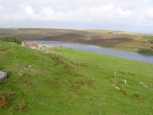
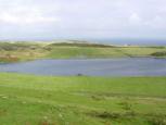
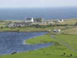
Loch Watenan lies in a rock basin that was
probably formed or increased by erosion of ice. The area near Loch
Watenan has at least 6 and probably more sets of standing stones several
of which have many stones missing. The best example with clear
rows still standing is Garrywhin (ND 314413). The loch is on the
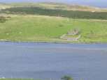
coastal side of a landscape stretching over Warehouse Hill to Yarrows
Broch that is covered in a huge range of monuments, buildings burial
sites and standing stones from many periods in history. Near to
the top of the Hill is the fort at Garrrywhin (ND313413) that may have
been no more than a cattle stockade but is huge with walls 8 - 12 feet
thick and portal gate stones still at the entrance. Water
runs into the loch from the surrounding peat covered hill and out by a
stream that feeds first into the mill pond at Whaligoe and subsequently
into the sea. |