

 | Caithness.Org | Community | Business | Entertainment | Caithness... | Tourist Info | Site Map |
• Advertising • Chat Room • Contact Us • Kids Links • Links • Messageboard • News - Local & Scottish • News - UK & News Links • About / Contact Us • Submissions |
• Bookshop • Business Index & News • Jobs • Property For Sale • Property For Rent • Shop • Sutherland Business Index |
• Fishing • Fun Stuff • George, The Saga • Horses • Local Galas • Music • Pub Guide • Sport Index • What's On In Caithness |
• General Information • B & Bs • Backpackers • Caravan & Camping • Ferries • Getting Here • Holiday Letting • Hotels • Orkney • Pentland Firth • Sutherland • Taxis |
| N E W S F E E D S >>> |
|
Caithness Field Club Bulletin |
|
GPS for FieldClubbers (by Ken Butler) Global Positioning Systems (GPS) have been available to the public for around ten years now and there is a good build up of capability. So it is a good time to comment on the usefulness of GPS in the context of Field Club members and activities. The one basic thing that a GPS unit does is to calculate where on the world it is. It can place itself generally within a few feet. Typically, in Caithness one can mark a place then go away and be guided back to the spot within a couple of hours to an accuracy of 1 metre. Coming back a year or so later with a different make and model of GPS is often accurate to within about 6 metres.
So one simple thing that can be done with a GPS is to state accurately the position of an archaeological artefact, bird�s nest, interesting plant or stile. All units can give the position in latitude and longitude or as an Ordnance Survey grid reference. For 1 metre nominal accuracy it has to be a 10-figure grid reference. The unit will have the capability to MARK the position by recording the location position in its internal memory. This memory item is called a waypoint or a Point of Interest. The GPS notes the location frequently, so if you walk it will note the sequence of positions and deduce the Speed over Ground and the direction or Heading. It remembers all the positions, so can display the Track of the walk on its screen. During a walk one can press the MARK button at intervals, at key points and at interesting places, to produce a set of waypoints recording the key features of the walk. These can be edited and tidied up later and made into a Route. Hence a Route is a set of waypoints and linkage instructions about the sequence in which the waypoints were reached. A typical Field Club outing can be recorded for posterity � or for repeating by others at a later date, by recording the Route. All the more expensive GPS units will link up to a personal computer so that the routes and waypoints can be stored on the computer. Likewise, routes and waypoints gathered by other people can be downloaded onto your GPS so that you can go around the routes that they have defined. There is even a new world-wide sport called Geocache-ing whereby people lay out routes with obvious recording point and the devotees follow the route and sign in their achievement of the target waypoints. There is software that will read the route data and plot it on a digital Ordnance Survey map so that the route can be printed on a copy of the map. See www.fugawi.com for a good example. But the software side has become difficult because there are so many definitions of the layout and style of waypoint and route data. One piece of software that tries to overcome the format problems and allows many sorts of manipulation of the data is the freeware program GPS Utility from www.gpsu.co.uk The more expensive units have a background map of all or part of the world and stored information about the locations of towns, railway stations etc. There can be a colour screen or just monochrome. It is also possible to download from a computer other maps to add to the internal collection. This uses a lot of memory, so modern units have provision for SD or Compactflash memory of the type used by digital cameras. Thus a good unit can have a display of the current location pointed up on a coloured digital Ordnance Survey map on the screen with the selected route marked in and showing the distance and direction of the next waypoint. Getting lost is becoming more difficult! |
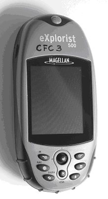 The unit receives signals from
special navigation satellites and needs to detect at least three and
preferably four to calculate a position. A modern unit is capable of
tracking 12 or 14 satellites simultaneously. A model designed for field
work, walking and small boating looks like a mobile phone and is hand
held. There are other types designed for in car road navigation or for
aviation or marine navigation but I will not comment on them. There is
another type which attaches to, or is built into a PDA (A Personal Digital
Assistant) which is usable in the field but not so versatile and focussed
as the field model.
The unit receives signals from
special navigation satellites and needs to detect at least three and
preferably four to calculate a position. A modern unit is capable of
tracking 12 or 14 satellites simultaneously. A model designed for field
work, walking and small boating looks like a mobile phone and is hand
held. There are other types designed for in car road navigation or for
aviation or marine navigation but I will not comment on them. There is
another type which attaches to, or is built into a PDA (A Personal Digital
Assistant) which is usable in the field but not so versatile and focussed
as the field model.


