| Caithness.Org | Community | Business | Entertainment | Caithness... | Tourist Info | Site Map |
• Advertising • Chat Room • Contact Us • Kids Links • Links • Messageboard • News - Local & Scottish • News - UK & News Links • About / Contact Us • Submissions |
• Bookshop • Business Index & News • Jobs • Property For Sale • Property For Rent • Shop • Sutherland Business Index |
• Fishing • Fun Stuff • George, The Saga • Horses • Local Galas • Music • Pub Guide • Sport Index • What's On In Caithness |
• General Information • B & Bs • Backpackers • Caravan & Camping • Ferries • Getting Here • Holiday Letting • Hotels • Orkney • Pentland Firth • Sutherland • Taxis |
| N E W S F E E D S >>> |
|
Caithness Field Club Bulletin |
|
The Great Caithness Meteorite? (by U Keith Gerry)
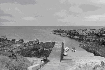
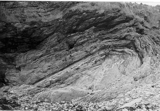
For the older generation the striking feature of Scarfskerry harbour today is the absence of the wreck of the Linkmoor which for many years blocked the entrance. As long as the Linkmoor was there it drew attention away from the harbour�s most striking and most ancient feature. This is the extreme and unusual tilt of the beds of the Middle Old Red Sandstone which is steeply down to the left on the left of the harbour and steeply down to the right on the right of the harbour as shown in Fig 1. In geological terms the harbour lies along the crest of a very pronounced anticline. If storm tides have been helpful a strip of un-eroded folded stone may be found at the foot of the cliff to the right of the slipway. Better still a near vertical section is to be seen in the cliff in line with this strip. The tightness of this fold is extraordinary as shown in Fig 2. The effect might be matched if a deep pile of tea-towels were pushed endways together, but if the same was attempted on a larger scale, say with a tall stack of bed-sheets, the bulk of the material would be too much to give such a tight fold. How did such an unusual fold develop in a widespread and immensely deep bed of sediment which has now formed hard rock? Caithness flagstone typically splits into such regular flat slabs that it gives the impression that the beds of the strata are uniform and parallel, even if they are now commonly tilted. This is widely the case but there are many exceptions. For example the beds in part of the cliff on the right of Lybster harbour are much contorted, while in the old quarry at Lieurary near Calder curved flagstone slabs can be extracted. During its long geological history the Caithness Old Red Sandstone was subject to much, generally minor, deformation. When this took place after the sediments had hardened, deep fine vertical cracks developed. These, according to their frequency and direction, were a blessing or a curse to the old quarrymen. There have also been large scale events in the past. Just off the east coast of Caithness lies the continuation of the Great Glen fault which has determined the line of much of the present coast, while 4 km west of Scarfskerry lies the north-south Brough fault along which the Middle Old Red Sandstone has sunk down with the Upper Old Red Sandstone on top of it, the latter now being preserved as Dunnet Head. Some of the big movements were going on progressively while the Old Red Sandstone was forming but the main movement of the relatively short Brough fault probably took place after the sediments had hardened towards the rock-like nature of today. The anticline formation at Scarfskerry must have happened when the sediment was in a soft clay-like state with the core just moist enough to flex without fracture and yet dry and firm enough to keep its shape once deformed. The beds of the Ham � Scarfskerry flagstone series are around 750 metres thick and below them lie further beds around 3 km deep. At any one time only a shallow section of these beds would have been at the right constitution to deform in the necessary manner. It is likely that a surface and probably local source of deformation accounted for the unusual formation. A possible explanation lies in a major meteorite strike. If the strike was violent enough, the initial rate of spread of the impact front would have exceeded the velocity of sound in the wet sediment. As the front spread the as-yet undisturbed material would have had no warning that it was coming and would have had to transmit the impulse, when it came, as if the material were a solid body. As the circumference of the material affected by the impact spread, so would the velocity of spread decrease until it fell below the local velocity of sound. From this moment the further soft material would be forewarned that an impact was coming and plastic deformation would take place to absorb its outward movement. The sudden stopping of spread would return an impulse echo back to the centre. This effect would not be confined to the surface layers but would continue down to the level at which the energy retained in the meteorite could no longer deform it. The result would be a cup-shaped distortion of the bedded material with the steepest folding in the sediment near the surface, which is once again exposed at Scarfskerry. The steepness of the anticline form would necessarily decrease rapidly with depth. The inward reflection of the impulse would likewise not be confined to the surface but would be continued downwards and its total effect might be sufficient to throw up some kind of peaked mound at the point where the meteorite struck.
If indeed this is how the very steep Scarfskerry anticline formed, the site could be of great importance in the study of meteorite impacts and their absorption. It would be valuable if more evidence for the strike could be found. Looking seaward at Scarfskerry there is a suggestion of a slight curve to the left in the line of the anticline and observation at very low tide or from a boat or by diving might confirm this. Confirmation of the curvature would give good support for a meteorite strike. If there were no east - west dip in the flagstone bedding along line of cliffs, another fold similar to that at Scarfskerry would appear further west and a walk along the cliff, or better a study from a boat would reveal it. However strata without dip are the exception rather than the rule in Caithness. If the east � west dip is down towards the west, the second exposure could now be below sea level and covered with later even-bedded material. If the dip is towards the east, the exposure would be from a deeper level and would be expected to be of a less pronounced form than at Scarfskerry. The second exposure is unlikely to be any closer to Scarfskerry than Ham and could be at or beyond the large geo which the maps mis-spell as Kerry Geo. If a second exposure can be found it would give an idea of the likely diameter of the impact ring and a chance of locating the position of the centre. It would seem probable that this is onshore and might be in the vicinity of Rattar house or Hill of Rattar. At Scarfskerry itself, where the cover is thin, there might be evidence for the landward line of the anticline in the form of magnetic or gravitational anomalies. Immediately above the unbroken fold at Scarfskerry the bedding is distorted rather than cleanly folded and higher still, at a level which is not exposed, the beds may have been torn apart. Continued deposition would have soon (in geological terms) buried the evidence for the event. If local contemporary surface beds could be traced the question arises as to what they might show. The deep body of yielding material provided by several km of sediment might have provided the easiest possible landing for a meteorite. The Orcadian lake in which the deposits formed was generally shallow, limiting the size of any wave and the lack of anything hard would have prevented the sudden generation of great heat or dust. The nature of surface evidence would depend on the depth of the Orcadian lake at the time. This varied cyclically from several meters to zero throughout the Middle Old Red Sandstone period. If the lake was dry at the time of the strike signs of a muddy splash might be expected or, if there was water, disturbance in the surface sediments would seem likely. The effects might be visible in exposures along the local cliffs where the dip is favourable. Contemporary beds may also appear in Orkney which might help to determine the extent of the area affected. The ultimate discovery would be to locate the body of the meteorite itself which may rest relatively intact somewhere below the surface. If the meteorite hypothesis is not accepted the question of the unusual fold at Scarfskerry still remains to be answered. Possibly it has been answered already and it would be interesting to learn where this may be found. Hopefully it will not make dull reading for it would be a pity to exchange the Great Caithness Meteorite for something very ordinary.
See More
Scarfskerry Photos |