

 | Caithness.Org | Community | Business | Entertainment | Caithness... | Tourist Info | Site Map |
• Advertising • Chat Room • Contact Us • Kids Links • Links • Messageboard • News - Local & Scottish • News - UK & News Links • About / Contact Us • Submissions |
• Bookshop • Business Index & News • Jobs • Property For Sale • Property For Rent • Shop • Sutherland Business Index |
• Fishing • Fun Stuff • George, The Saga • Horses • Local Galas • Music • Pub Guide • Sport Index • What's On In Caithness |
• General Information • B & Bs • Backpackers • Caravan & Camping • Ferries • Getting Here • Holiday Letting • Hotels • Orkney • Pentland Firth • Sutherland • Taxis |
| N E W S F E E D S >>> |
|
Caithness Field Club Bulletin |
|
Early History of
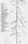
Strathnaver The history of human settlement of the north of Scotland begins very recently in comparison with the long, slow development of mankind in the rest of the world. There is a map at the end of this article to help locate the artefacts described. Throughout the Ice Age - glaciers advanced and retreated across Scotland - the climate slowly changed from Glacial - to Tundra - to Temperate - and back again. In each Temperate period woodlands spread in from the Continent. But, over this long time, the north of Scotland remained uninhabited by animals or humans. By about 10,000 years ago (8,000 B.C.), the ice finally melted, leaving the land which would be quite familiar as todays Straths, Lochs and Mountains. The early hunters of the Mesolithic Age, with stone axes and wooden spears, lacked the ability to move into the Temperate Latitudes. But Neolithic Man (the early farmers), with the development of improved stone working techniques over the years, developed a whole new range of weapons and tools capable of advancing their standard of life. The immediate result of so much ice melting was that the sea level rose by approximately 200 feet, thus covering much of the coastline. At the same time, the land, free from the great weight of ice, also began to rise. For the next few thousands of years, the sea levels fluctuated. Today the levels are at low - and the "old" high level beaches (raised beaches) can be seen in many places round the Scottish coasts. Good examples locally can be seen at Helmsdale, Brora and Golspie. This was the time the
first humans found their way north. By this time a wide range
of mammals, birds and insects would also have colonised the North. With such an amazing time scale covered, I would like to start with a brief review of the ages involved. Mesolithic Period.
(7000 - 4000 B.C.) Neolithic Period. (4000
- 2000 B.C.) Chambered Cairns were
probably in use for a period of 2000 years. A wide variety of styles still
exist - some circular - some elongated - some with long or short horns. As
building skills developed over the years, the chambers tended to become
larger and more complex, some introducing corbelling. These cairns
continued to be used over many years, much like family vaults. Most have
been looted over the ages. However a few have survived intact. Excavations
normally reveal human and animal bones - sometimes burnt -pottery pieces
and other Neolithic artefacts. Bronze Age. (2000-500
B.C.) By comparison with the massive Chambered Cairns of the Neolithic Period, the Bronze Age burials were modest affairs - buried individually in flagstone coffins (called Cists) and then covered with stones - but not always. Bodies were buried with knees up to the chin, making the cists quite small. Artefacts found in such cists included pottery. Yet another characteristic of the Bronze Age were the early carvings on some stones - sometimes cut into the stones of the cist. These are known as Cup Marks or Ring and Cup Marks - thought possibly to have some religious symbolism. Iron Age. (500 B.C. -
500 A.D.) These Iron Age peoples developed a whole range of Look-out Towers or fortified structures -Hill Forts - Brochs - Duns. Their commonest dwellings would appear to be the Round Huts (i.e. today's Hut Circles). At this time, Souterrains - long underground tunnels - appear, usually running outwards from these Hut Circles. Some think they were used as cold storage larders; others think they may have a religious connection. Early Christian Period.
(500 A.D. - 1100 A.D.) Medieval Period. (1100
A.D. - 1600 A.D.) Highland Clearances. Strathnaver had two. 1814 and 1819. Patrick Sellars, a professional lawyer who had been Procurator Fiscal, decided to make a fortune for himself in helping the landlords clear the land. His harshness and his burnings to clear the southern straths led to his becoming the most hated man in the Highlands. It was rumoured (and widely believed) that his body became riddled with lice as a result of the many curses put upon him. William Young was responsible for the northern Strathnaver clearances - where no trace of burning has been found at Rossal, Dunvidon or Borgie. There the people left voluntarily. Strathnaver Clearances. The River Naver. Borve Castle In Medieval times Borve Castle was a major stronghold of the Clan Mackay who had invaded Sutherland. As early as 1370, the Earl of Sutherland described them as the 'Ancient Enemies'1. Hostilities between the two clans ranged from minor raiding and looting to finally a major war involving thousands of men. The battle of Druim-na-Coub was fought directly below the spectacular peaks of Ben Loyal. Borve Castle was destroyed by Sutherland's army in 1555, after a series of Mackay raids while the Earl of Sutherland was in France helping Royalty. The Queen Regent (mother of Mary, Queen of Scots) ordered the Duke of Sutherland to destroy the outlaw as he had ignored a summons to appear before her. Castle Borve had always withstood all previous attacks, but, for the first time, modern progress was to defeat them. The brave and able commander, Rory Mor Mackay, was dismayed by the appearance of a large cannon, pulled all the way overland from Edinburgh on the cast coast. Sited on a higher elevation on a nearby cliff, a long bombardment reduced the castle to a ruin. Forced to surrender, Rory Mor Mackay was hanged on the spot and the castle was destroyed beyond further use. To the cast of Borve Castle and Bettyhill, lie early Neolithic cairns. Proceed 200 yards from the cattle grid on leaving Bettyhill (towards Thurso), to reach some sheep pens on the left. Parking here, one can walk up the hill to the north for % mile to where there is a substantial round cairn probably a burial cairn, but from the earlier ages. Proceed to the top of the crest where there are another 2 round burial cairns, also of the earlier period. One has been vandalised to some extent but the other is quite substantial and in reasonable condition. Before we reach the Clearance Village, just off to the left of the road, lie 2 Neolithic Long Cairns. The left hand one is very ruinous and has unfortunately been used as a farmer's dump. The other one is quite elaborate with an entrance passage and several chambered areas which are quite clear and can be walked between. Again its tail leans out of line by 10% -possibly again by later additions. Between the 2 Long Cairns is a very striking and most unusual circle of Standing Stones. I know of no other example in the north. The Chambered Cairn at Achnavanish has a horseshoe part circle near-by. The Clava Cairns in Invemessshire have several Stone Circles with Cairns. Aberdeenshire has Stone Circles, often with Recumbent Stones in the ring - looking rather like altars. No one knows the purpose of these. Invernaver Iron Age
Broch, Settlement And Burial Sites. Also to be found are large lines of stone rows - short stretches of drystone walling - it is a puzzle as to the purpose of these! Coillen A Borgie. Achanlochy Clearance Village. At first sight, the houses in the village appear to have been placed at random. However, because wheeled vehicles were not then in use, there was no need for streets. Houses were simply built on any well drained site, usually up the slope rather than on the valley floor. Here are 2 of the finest corn kilns - still in excellent condition - and a main long house and outhouse. Corn Kilns Above the village is the quarry, but a lot is left to your imagination as to what is scree and what is quarried stone. Achanlochy people were evicted in the third and major clearance of
Strathnaver in 1819. The village is best visited in the Spring, before the bracken begins to grow. Further North Drochaide Iron Age Broch. With some surprise, you will realise that the walls stand to 10 feet above the floor - infill, on the original floor, of fallen stones and other debris is 5-6 feet deep. It is estimated that this broch has a containment of 4,000 tons of rock. Unusually, for a hill broch, this one had an artificial moat - a drainage burn was diverted to supply the water. A dam and moat works are still clearly seen. However this is now thought to be water for an early fish farm. Hut Circles Skelpick Neolithic Chambered Cairn 70 plus yards long - it also has 2 horned tails now sinking into the peat. The chambers are open - have to be with a birch tree growing out of the main chamber (this has now been removed). You will immediately be struck by the size of these chambers - one 12x11 feet and another 9x8 feet. Closer examination shows that the chambers are extremely well built. Both drystone dyking and the vertical slabs are clearly obvious. It was excavated in 1867. The northern chamber survived and was left intact - the entrance carefully sealed by horizontally laid flagstone -seems it is possibly the original sealing stone from Neolithic time rather than later. The first chamber leads into an over-lain lintel supported by overlaid
flagstones - a system known as corbelling . This dates the chamber as a
later development. This corbelled roof has survived to today. Two other long cairns, completely ruinous, are apparent on this side of the bum. These appear of cruder construction - possibly earlier in age. NOTE Several perfect examples of corbelling survive today in the chambered cairns at Loch Calder. Iron Age Workings Long Cairn Above The Skelpick Cairn. A new bridge across the burn directly down from the white house, allows easy access to the Skelpick Cairn, the Iron Workings and the upper Long Cairn. Skelpick Village Summer Camp Clearance Cairns. Hut Circles Again And Clearance Cairns. In this area is a hut circle complete with 3-4 feet high walls. The entrance of portal stones is still in place, making it one of the best conditioned to be found. Internally it has, set back from the door, a smaller circle of foundation stones. We do not know the purpose of these! Just beyond, is a large cone shaped mound, 30-40 feet high, with a circle of stones all round the base and, 5-6 feet from the cone top, another circle of stones. Its purpose is also unknown. However some think it may be a burial mound. Dunvidon Neolithic Chambered Cairn Dunvidon Iron Age Broch Dunvidon - The Clearance Village. From Dunvidon to the mouth of the river, these occur at regular intervals down the strath. With the exception of the lower areas, these are again in deep heather. Hut circles also seem to exist all the way up the strath. Rossal The site has been well preserved by the Forestry Commission, with information boards and wooden walkways. A few Iron Age hut circles can be found at the forest edge. Follow the marked trail to the various remains of long houses, barns,
out-houses and a souterrain. See also the monument to Donald Macleod at Red Brae, opened by the late
Ian Grimble in Langwell Iron Age Broch. |
|
|
Below the child's grave, by about 50 yards, we find a small monumnet to:
|
"DRAPEAU" |
There is a letter from David Midwood to Caithness Field Club re Graves at Strathnaver
|
Thank you for your letter Societies like
yours are so important and I respect your interest and endeavours to
collate local history. So much local historical knowledge dies with each
generation. I was lucky enough to have had most of my Spring and Autumn
holidays at Syre and could never hear enough of the local history; all
those truly great men and women who were so proud of their heritage are
now dead and buried. The walled graveyard containing the grave of Elsa Dankwerts is, as you will have seen, on a very dramatic site. The inscription on the grave stone tells the story of a tragedy. She died, aged eleven of leukemia in 1911 (from memory). Her family were the last tenants of Syre before the Duke of Sutherland sold to my Grandfather. They themselves built on a large extension to the lodge and a good deal of the china still in the lodge was theirs. The family did contact my Mother, before she died in about 1974, asking if they could be given possession of the grave yard. I never understood why my mother refused them. The Dankwerts were Dutch, but all the records of their time at Syre must have been removed when they left. If you were interested more would be discovered at Dunrobin I would think. Good luck with your quest and I would be happy to help you in anyway possible in the future. Yours sincerely David Midwood |
| Dun A full circle of base stones, plus a � circle bank, are quite clear. 1 wonder whether it is actually a hut circle with added fortification on the bank - a later development. Carnachy Iron Age
Broch. Preclearance Village Cairn Early Settlement Carnachy North Broch Achargary Neolithic Chambered Cairn And Cairns. In closing, I would suggest that it is amazing that, in the few miles explored, we have covered from Mesolithic peoples - 8000 B.C. - to the present day, covering countless ages - but showing that this land has been inhabited for all this considerable time. P.S. Much more remains to be discovered!! |


