| Caithness.Org | Community | Business | Entertainment | Caithness... | Tourist Info | Site Map |
• Advertising • Chat Room • Contact Us • Kids Links • Links • Messageboard • News - Local & Scottish • News - UK & News Links • About / Contact Us • Submissions |
• Bookshop • Business Index & News • Jobs • Property For Sale • Property For Rent • Shop • Sutherland Business Index |
• Fishing • Fun Stuff • George, The Saga • Horses • Local Galas • Music • Pub Guide • Sport Index • What's On In Caithness |
• General Information • B & Bs • Backpackers • Caravan & Camping • Ferries • Getting Here • Holiday Letting • Hotels • Orkney • Pentland Firth • Sutherland • Taxis |
| N E W S F E E D S >>> |
|
Caithness Field Club Bulletin |
|
SAILING DIRECTIONS FOR THE NORTH
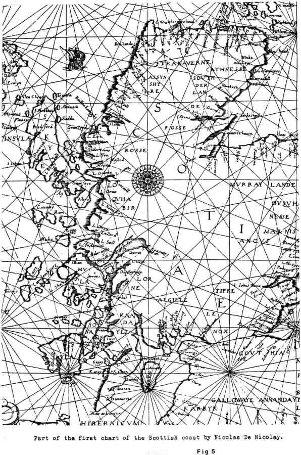
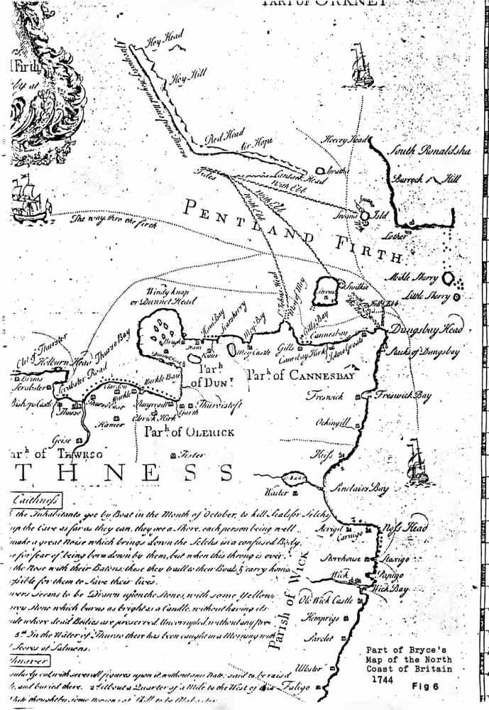
COAST For hundreds of years coastal sailing was the most convenient way of travelling. Boatmen amassed detailed knowledge of the tides, currents and hazards in their locality. This lore was passed on in some easily remembered form, such as, "The tower of Mey a handspike high, the Men of Mey you may pass by". Simple written instructions for an ocean voyage from Norway to Greenland are given in the 12th century Landnamabok; "From Hernor in Norway one is to keep sailing west for Hvarf in Greenland and then you will sail north of Shetland so that you can just see it in very clear weather, but south of the Faeroes so that the sea appears half-way up the mountain slopes, but on the south of Iceland so that you may have the birds and whales from it." It was not until the early 16th century that detailed instructions were compiled for the coast of Scotland. About 1540 Alexander Lindsay produced his "Rutter of the Scottish Seas". The word Rutter is derived from the French routier which is cognate with our route. Sections two and three of the rutter cover the coast from Leith to Duncansby Head and from Duncansby to the Mull of Kintyre. Now Alexander Lindsay was probably a lowland Scat who acquired his information about the north and west coasts from some local expert. The most likely candidate was John Elder, who was born in Caithness and was brought up In Skye and Lewis. In 1543 Elder sent a letter and a 'plotte' or map of Scotland to King Henry VIII. As a cartographer he is likely to have had the type of information which Lindsay needed. For easy reference, the material in the rutter is collated under five headings. The course of the tides. The time of flood and ebb tides The strykinge (landfall) of coasts The kenninges (distances) from one headland to another The havens, roads, sounds and dangers. A few of the local entries under the above headings will give an idea of how concise and accurate the rutter was: 1 . Betuixt Dungisbe Head and Quhyniknap (Dunnet) Head it flowethe south southest and north northwest. Betuixt Quhyniknap Head and Wraith Head alongis the cost of Caithness and Strath Naverne it floweth est southest, west northwest. 2. In Pethland Fyrth and in the Iles of Orknay the moone southest, full sea. 4. From Dungisbe Head to May Head northwest, v mylle. From the May Head to Quhyniknap Head northwest to west, vj myle. De la pointe de Quhiniknap, a la pointe d'Holbrune oest, vi mille. From Brumisnes to Arquhytin (Whiten Head) west, ij kennings. (A kenning was a distance of 14 Scots or 20 English miles) 5. In the middes of Pethland Fyrth betuixt Dungisbe and Orknay there is a great daunger causit be nepe tydis whiche is called the Boir. To avoid the dounger ye sall mak your course from Dungisbe northwest till you come north to est from Stroma. At the north end of Stroma is a greater daunger called the Swelle whiche Is the meeting of iiij or v contrary tydes with great circulationne of watter causing a deep hurlepoole in the middes, dangerous for all shippis both great and small. Betuixt Sw'nna and Ronaldsa are great dangerous poplynis of watter called the Hoppers. On the south west syd of Ronaldsa is a dangerous tyde called the Crelis. A halff a myle from the May Head lyeth dangerous rockis called the Men of May. Betuixt Quhiniknap Head and Hobrun Head is a good rod callit Skarbster. The single French entry in the above extract is an apt reminder that Nicolas de Nicolay used Lindsay's rutter to produce the first chart of the Scottish coast in 1583. William Lithgow crossed the Pentland Firth in 1629 and mentioned the whirlpool "that whirleth ever about; cutting in the middle circle a devalling hole, with which if either ship or boat shall happen to encroach, they must quickly either throw over some thing into it, as a barrell, a piece of timber, and such like, or that fatall Euripus shall then suddenly become their swallowing Sepulcher. A custom which these bordering Cathenians and Orcadians have ever heretofore observed." It has been suggested that this custom is a relic of symbolic sacrifice and sympathetic magic, but more likely it was a method measuring the steering correction for the boat in relation to the line of the current, for all the jettisoned items were buoyant. In 1744 Alexander Bryce produced an outline map of the north coast and he filled the blank areas of the chart with rutter-like notes. In addition to the navigational entries, there are also sections on the Rarities of Caithness and Strathnaver. The text is reproduced in full, for it contains much factual and interesting information. A MAP OF THE NORTH COAST OF BRITAIN FROM ROW STOIR OF ASSYNT TO WICK IN CAITHNESS. By a geometrical survey; with the harbours, rocks, & an account of the tides in the Pentland Firth, done at the desire of the Philosophical Society at Edinburgh
Some Remarks on the Tides &c in Pentland Firth Winds from NW to N raise the greatest storms on the Strathnaver, and North coast of Caithness. Winds from SSW to W raise the greatest flood's in Pentioncl Firth, hasten ar,d continue them longest. Winds from NE to SE have the contrary effect. Winds from NNW to NE make the greatest ebb-tides Nep-tides In Pentland Firth are nothing violent, but Spring tides run with great rapidity. Ebb tides (especially with a wind at W) are more dangerous than the floods. The Flood sets in from W to E and tis high water in Thurso Bay on the day of full and change, 35 min. after Viii. Sometimes it may be a quarter of an hour sooner or later according to 2 & 3. But the strength of the flood is not spent for near 3 hours after this in the middle of the channel and the strength of the ebb-tide continues to run for the same space of time, after the flood begins to make on the shore. The Boar of Dungsby is a very hot tide that begins to make with 2 hours of flood off the west side of Dungsbay Head and shoots over to the Islands of Stroma. Occasion'd by a ridge of rocks in that direction, that ly about 8 fathoms under water with the flood. With a Spring-tide and wind from NE to SE the Boat is most kindled (as they phrase it) the current of wind and tide being then contrary raises such a terrible sea as makes it extreamly dangerous, if not impossible to pass it. Hell Ebb is another violent tide, that makes off the NE part of Dungsbay Head and shoots over in a direction more easterlie that the last. Tis most dangerous with winds from SW to NW. The Men of Mey is a ridge of rocks lying off St. John's Head, under water with the flood, but appearing here and there at ebb, these rocks give rise to a very hot tide that makes off St. John's Head and shoots over to the Island of Waes; this tide is most dangerous at half ebb. With the ebb there runs off the northermost part Of Stroma another very hot tide, and leads over, as the former, to Waes. This has altogether the appearance of a land breach, and a stranger wou'd take it for one continued ridge of rocks, but the ground is quite clear, and water for ships of any burthen. As the flood passes by the northend of Stroma, it occasions a whirling on the NE side of the Island, which is called the Swilkie of Stroma. The like happens at the Island of Swona both with f loods and ebbs, and is called the Wells of Swona into which if ships or boats should fall and not be able to get out for want of wind, they may safely allow themselves to be carried up and down till the strength of the tide be spent, and then may pursue their course. With two hours of ebb from the north end-of Stroma and from St. John's Head there run very hot tides (those mentioned in 10 and 11) which shoot over to the east of Red Head where they meet with other two leading up from Swona and Cantac Head, when joined they rise to so very great height (especially with a wind NW) as makes it exceeding dangerous if not impossible to pass them. Tis best to cut them at the beginning of the ebb, they're most dangerous from half ebb, till it be near spent and a good deal of flood upon the shore. After joining their course is NW. Sailing between Cannesbay and Stroma tis necessary to bear well up into Gills Bay to shun a ridge of rocks running out 1/4 mile from the SW point of Stroma, to clear the Men of May steer midway between St. John's Head and Stroma, till you can see the roof of Mey Castle when thus far you're out of all danger and may pursue your westward course. The safest way for westward bound ships is to keep pretty near Noss and Duncanbay Heads and to sail by the north end of Stroma. When eastward bound keep the same course especially if the wind be scarce, and so you'll shun the danger of being born on the Lother and Meikle Skerry by the flood tide where several have actually stranded. Off Dunnet Head with the ebb and wind at W or with the flood, wind NE there's always a tumbling sea which continues from half tide to half tide. Off Brims Ne-ss there lys rocks under water, but if you keep ye breadth of a sail of Dunnet Sands without Holborn Head there's clear ground and water for ships of any burthen. Off Cape Wrath, with ebb and wind at W or with the flood and wind at E there's always a rough and swelling tide, to shun it ships stand out to sea or bear less sail till it's strength be spent. Tis observable that the floods or ebbs shou'd carry you so sway as a stranger wou'd think it impossible to escape being dashed against a Rock, yet these tides will shoot you off almost every rock and Head in Pentland Firth. Of The Harbours Along The Coast of Caithness & Strathnaver From the Ord of Caithness to the Water of Wick there is no harbour and but few places (such as Dunbeath Water, the Burn of Latheronwheel) where boats can enter. In the Water of Wick ships of all burthen may ly safely, especially if the storm blows not from the east. Staxigo is the place most frequented. ships in this part of the country and might be made a safe winter harbour for a few ships at a small expence. There's no entry except with the flood, but ships anchor on good ground before the harbour till the tide makes.
Sinclair's Bay is all clean ground and ships may cast anchor in any part of it at about a cables length off shore. Tis often necessary to spend the flood here or in Freswick Bay, when you design to pass through the Pentland Firth, the proper time of entry being with the ebb tide. If after having entred the Firth the flood should come upon you, it may be spent on the east side of Stroma or Dunnet Head tacking up and down, but take care to keep still within the eddie tide. In Gills Bay there's anchoring ground and ships if needfull may ly on 5 or 6 fathoms water below Gills Hall. In the mouth of Murkle Bay ships of small burthen have anchor'd With a spring tide small ships enter Thurso Water and ly safely. Scrabster Road is a very good harbour where ships of any burthen may ride out any storm upon 6, 7 or 8 fathoms water, the anchoring ground is good and besides for the better securing of ships there's two iron rings fix'd to the rocks on the shore. Behind Torrisdale Head on the west end of the sands ships enter with the flood and ly safely. On the SE side of Island Comb there's a small creek, where a few ships may ly safely on 8 or 9 fathoms water. Between the two Rabbit Islands ships may anchor on 4, 5 or 6 fathoms water, land lockt by Island Roan at about a cables length south of this there's a bank of sand., At loch Eribol, in Camisindown Bay, a number of ships may ly very safely on a great depth of water, in the SE part of the bay. Above Island Chorie there's good anchorage for any number of ships on 12 and 14 fathoms water. Its proper (in case of rans of wind blowing down from the mountains) to ly at some distance from the Island, so as to be able to clear it. When ships have advanced so far as to be off two rivulets that run down from a hill on the west side of the Loch, that is the proper place to drop anchor. See the map. In the south side of Rispan Bay a few ships may ly safely. Loch Hether and Loch Inchard are safe harbours, the entry and place of anchorage as in the map. In loch Laxford wherever you can enter, there's good ground. Ships commonly ly behind a small island in the south side of the loch. See the map. In Tarbot Bay theres safe anchorage on 4 or 5 fathoms water. Ships sometimes drop anchor off a little sandy bay on the E end of lsl'd Hando. Badcal is a very safe harbour, ships ly (on 12 fathoms water) as in map: by rason of the number of islands before and within this harbour, a stranger cannot enter without a pilot. Loch Calva is as safe a harbour as the former, the entry easy and clear. Ships ly on 15 fathoms water as in the map. Loch Shark is abundantly safe. Ships ly on the SE side on 8 & 9 fathoms water, about 1/5 of the breadth of the entry from the north side there lies a blind rock. In Kylescow the places of anchorage are safe: by reason of the narrowness of the Kyle the tide runs current and without due care will bear ships beyond the harbour. No entry but with the flood for that reason. Loch Need is a very good harbour, ships ly as in the map, on 7 fathoms water, there are some blind rocks and skerries on the west side of the entry. Almost all the lochs in Strathnaver abound with plenty of oysters. The prickt lines show the best harbours & how to enter them. Rarities in Caithness On the rocky coast near Latheronwheel there's a large cave, to which the inhabitants goe by boat in the month of October to kill seals (or selchs) they enter it about the middle of the night, and having row'd up the cave as far as they can they goe a shore, each person being well provided with a baton and properly station'd they light their candle and make a great noise which brings down the selchs in a confused body with frightfull shrieks and cries. The men are obliged to give way to these for fear of being born down by them, but when this throng is over they kill as many as they can of such as straggle behind by knocking them on the nose with their batons, these they traill to their boats & carry home. If their candle shou'd be put cut or a gale or wind blow off the sea tis hardly possible for them to save their lives. At Noss head there's a salte quarry where the likeness of beasts and flowers seems to be drawn upon the stones with some yellow substance like gold leaf. In several places of Caithness there's grey stone which burns as bright as a candle without having its figure changed by the fire. On the SE part of Stroma Island there's a Vault where dead bodies are preserved uncorrupted without any preparation. Some of them have been lying there these threescore years and still entire. 5th In the Water of Thurso there has been caught in a morning with two or three daughts of a net 2 thousand, 5 hundred and some odd scores of salmons. Rarities In Strathnaver In the churchyard of Far there's a whin stone 6 foot high regularly cut with severall figures upon it without a date, said to be raised over a son of the King of Denmark's, who was killed in battle, and buried there. About a quarter of a mile to the west of this there's a rock the stone of which is of a pure bright white, thought by some persons of skill to be alabaster About 6 miles SE of loch Eribol there's an antient building In the form of a cone, called in their country language Down Dornadil (Dornadilla's Tower) said to have been built by the Scots King of yt name, this they think the more probable as he was a great sportsman and here is surely the best deer hunting in the world; this tower is double & built of large dry stone with a spiral stair, between the outer and inner walls are beds for the hunters and their dogs, with places for their bows and arrows. To the east of Durness there's a very large beautiful cave called the Smow. After you have enter'd It there's an opening in the rock like a door and within this a fresh water lock of great depth but exceeding dark. Some of the inhabitants scramble up to this opening and fish trout. What the extent of ye loch may be (tho some have had the courage to try it with a boat and candies) no body knows. Near Durness there's a well the water of which continues fresh and pure for twelve months after it is taken from the spring. At Sandwit there's a wood of hazels about 4 Inches in height and none of them near so thick as a goose quill, bearing nuts regularly every season. In Island Handa there's a little Loch the water of which whitens and washes linnens as well without as any other water with soap, of which an old man In the island gave us many instances. Several of the rocks and isl'ds about Durness are marble TO THE Rt HONble THE EARL OF MORTON This map is inscrib'd by his Lordship's most obed't & most devoted humble servant. Alex'r Bryce That the information in Bryce's map was right up to date when it was produced can be proved by the inclusion of the story of catching 2,500 salmon in the Thurso. For according to the men involved in netting the fish, George Paterson, George Swanson and Donald Finlayson this took place on 23rd July, Old Style, 1743 or 1744. Bryce's map also seems to have been used by Bishop Forbes on his visit to Caithness in 1762, for background material for his diary. The story of seal hunting at Latheronwheel is lifted word for word. REFERENCES
|