| Introduction | The Castles | Images | Links | History Of Caithness | Glossary | A to Z of Caithness |
• Reconstruction Paintings • Ground Plans • Area Plans • Photo Galleries • Non-Caithness Castles Paintings |
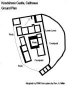
| Knockinnon Castle, Caithness Map Ref: ND 181315 Landranger Sheet 11 Knockinnon Castle Photo Gallery Introduction
As you drive North after passing through Dunbeath, the dominant Hill of Lychrobbie is obvious to your left and it is on the lower slopes of this hill, that the remains of what was to be a great castle can still be seen. It is situated near Cnoc Heara farm about 300 ft above sea level and some 300 yards inland from the shore. The position guards the whole coast from Berriedale to Clyth and the Dunbeath and Latheronwheel Straths.
It is said that Knockinnon Castle was started by William, 2nd Earl of Caithness who fell at the battle of Flodden in 1513 and so it was never completed. It would have had the usual central thick-walled keep and a good number of stone built buildings to provide, stables, smiddy, chapel, brew houses, workshops, armoury, accommodation etc. There would have been an outer courtyard at the lower level to the NE of the site and this would have contained a number of dispensable timber buildings. A substantial wall of enceinte, rising from a cliff edge some 6 or 7 ft in places, would have surrounded the whole complex making it a formidable fortification indeed. Macfarlane (1906-08) quoting from a description of the parish about 1726 states that “at the place designed for the entry to this great building, there was a large broad causeway begun and it is reported that the causeway was carried on to the town of Thurso. That part which was made in the Causeway mire (ND 164496) is obvious to any who travel that way” Tradition also states that an earlier castle was built on this spot by Einer, when Caithness and Sutherland were still part of the Norwegian realm. Einar was the youngest son of Rogenwald “the mighty”. It is also suggested that the remains of an old parish school lie on a spur just to the South of the castle although other reports say that this may be the footings of a traditional crofting long-house. It is also believed locally that a church or chapel stood here at one time. So the keep your eyes peeled folks the next time you pass this spot, and with Andrew Spratt’s painting in your mind you will be able to visualise what might have been an impressive stronghold.. References:
|