|
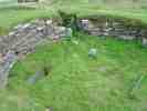
Nybster Broch - Background From the Canmore Database of RCAHMS (ND 3702 6314) Broch (NR) OS 1:10,000 map, (1973) Nybster Broch was excavated by Sir Francis Tress Barry about 1900, revealing neither guard chamber nor mural cells. It has in internal diameter of 23ft and a wall thickness of 14ft. In 1910 the maximum height of the walls was 5ft 3ins. The broch is defended by a possibly later forework and the whole is fronted by a ditch about 20ft wide which cuts off the promontory on which the broch stands. To seaward of the broch practically the whole promontory is covered by well-built out-buildings, oblong, circular, and irregular in plan. Finds include a fragment of 2nd century Samian ware, as well as the more usual bone and stone objects. A Young 1966; RCAHMS 1911, visited 1910. Nybster Broch is as described and planned above. Although there is no trace of a ditch cutting off the promontory, there are remains of secondary defensive banks and walls, probably contemporary with the broch forework. A modern monument to Sir Francis Tress Barry has been constructed immediately E of the broch, destroying several outbuildings. Two mounds at the seaward end of the promontory are probably excavation spoil heaps. Resurveyed at 1:2500. Visited by OS (R D) 14 September 1965 Classification of Roman material. A S Robertson 1970. A site of major signifcance in the study of the development of the broch in that it comprises the ground-galleried block-house of a pre-broch promontory fort, a solid-based broch, and a post-broch settlement. The block-house, which displays broch-like features, including a passage checked for two doors, is probably to be dated not much before the first century BC if not within it. R G Lamb 1980. Several sherds of 'broch' pottery were recovered from the upcast from illicit digging within the broch interior. Finds with investigator. R B Gourlay 1981. A promontory broch with a ditch. In good condition due to recent renovation. C E Batey 1981. Nybster Broch is generally as described and planned by the previous authorities. The excavations were not backfilled and most of the walling is exposted, albeit heavily overgrown. The previous field investigator noted 'secondary defensive banks and walls' immediately W of the forework. These have been completely levelled, but they were almost certainly fairly modern, perhaps spoil heaps, as the RCAHMS did not plan them, and they formed no logical pattern with the broch and its outer defences. Revised at 1:2500. Visited by OS (N K B) 22 July 1982. ND 349 615; ND 370 631 As part of a wider study of Iron Age Caithness, the brochs and settlement complexes at Keiss Road, Wick (ND36SW 1), and Nybster, Wick (ND36SE 4) were surveyed in September 2004. The sites were previously investigated in the late 19th century by Sir Francis Tress Barry. Sponsors: Highland Council, Caithness and Sutherland Enterprise, Caithness Archaeological Trust, AOC Archaeology Group, University of Nottingham, NMS. J Barber, A Heald and J Henderson 2004 |
21 July 05 |
