| Caithness.Org | Community | Business | Entertainment | Caithness... | Tourist Info | Site Map |
• Advertising • Chat Room • Contact Us • Kids Links • Links • Messageboard • News - Local & Scottish • News - UK & News Links • About / Contact Us • Submissions |
• Bookshop • Business Index & News • Jobs • Property For Sale • Property For Rent • Shop • Sutherland Business Index |
• Fishing • Fun Stuff • George, The Saga • Horses • Local Galas • Music • Pub Guide • Sport Index • What's On In Caithness |
• General Information • B & Bs • Backpackers • Caravan & Camping • Ferries • Getting Here • Holiday Letting • Hotels • Orkney • Pentland Firth • Sutherland • Taxis |
| N E W S F E E D S >>> |
|
Caithness Field Club Bulletin |
|
FRESWICK LINKS, CAITHNESS: SURVEY
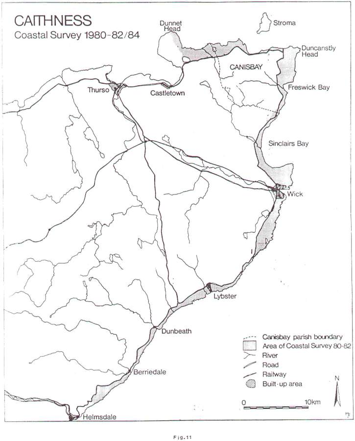
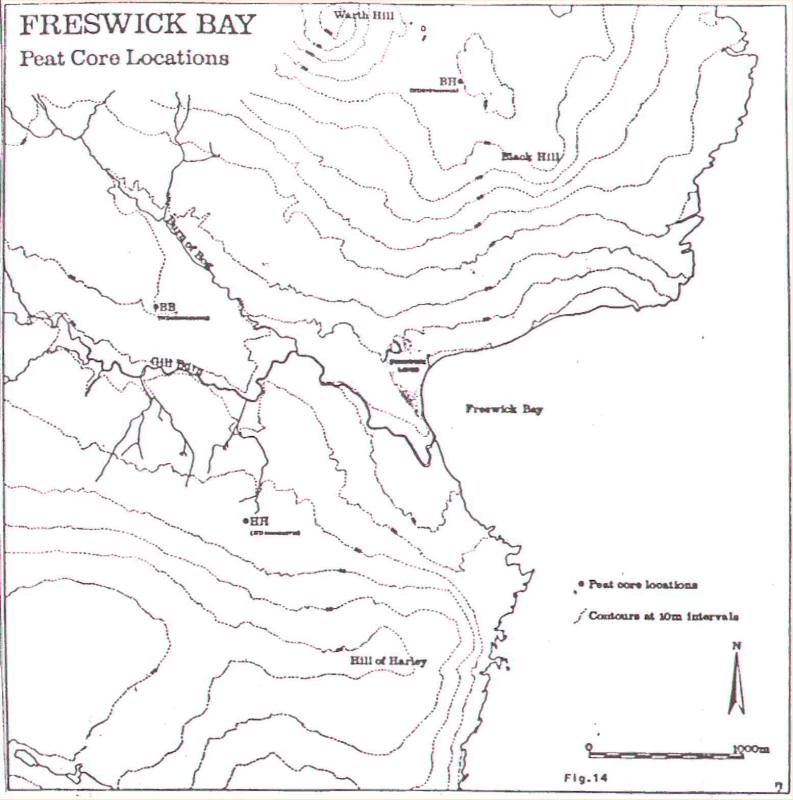
1984 In April 1984, a short programme of survey was undertaken at the late Norse site of Freswick Links, on the east coast of Caithness. A varied programme of work was undertaken, ranging from examination of the eroding zones as previously distinguished1 and contour surveying, to the taking of three pollen cores and samples of pottery for thermoluminescent dating. The provisional results of this work are outlined here. THE EROSION ZONES A number of the areas of erosion remained virtually unchanged since 1982, such. as Zones A, B, H, M, N, P, R, S and V. In these areas, very few finds were recovered and the general appearance of sand banks supported by grassy tussocks remained. However, several of the other areas distinguished showed signs of continuing erosion. Further record photographs of these eroding areas were taken. In Zone C, increased erosion was noted at the cliff edge and in the two northerly extensions first recorded in 1982. The finds included iron and industrial waste with a few sherds of grass tempered pottery, all collected from the loose, eroding sand. Zone D was distinguished further by collapse at the spur at its southern end and a cutting back of the cliff section to join with the excavation Area 4, opened in 1980 and placed approximately 1.5m back from the cliff edge. Finds from this zone were not extensive but some 54 sherds of grass-tempered pottery were recovered. in Zone E, the remedial work of 1982 survived through into 1983 but by 1984 slippage and further erosion wore noted behind the timber battening and rubble protection placed in 1982, and further stonework exposed. To the south in Zone F, noticeable cliff-top erosion was recorded. Finds from these areas included pottery and industrial waste. Zone G, although generally as previously recorded, had considerable slippage and produced four sherds of steatite vessel in addition to a bone pin and pottery. In Zone J, undermining was evident and in Zone K, very extensive collapse caused by undermining could be seen at the north and south edges of the zone in addition to the scouring of the midden along the base of the area. The zone produced a copper alloy ringer ring, glass bead and pottery amongst other, more modern, items. A western extension to this area indicated increased erosion. Zones L, T and U, although similar in their condition to 1982, exhibited traces of erosion, while Zone Q had extensive traces of erosion at the extreme west edge of the zone revealing midden deposits in situ above the present lower level of the zone. Finds from this zone included lead, copper alloy fragments and abraded pottery, in addition to more modern finds. The 1984 erosion survey has highlighted the problem of the continuing erosion at the site, which in some cases, particularly around Zone E and Zones K and Q, has been considerable since 1982. The recovery of a large number of finds has continued in 1983, including a finely decorated copper alloy bell of early Medieval type from Zone L. Extensive stabilisation of major parts of the site is now urgently required, particularly at the cliff edge, on the lines of the recommendations of Dr. J. S. Smith of the Department of Geography, Aberdeen University, to the Scottish Development Department. It is fervently hoped that this work will be undertaken within the next two years under the auspices of the S.D.D. (Ancient Monuments Branch). THE CONTOUR SURVEY In the 1984 season, the contour survey area of 1980-82 was extended southwards to include excavation Areas 13 and 14 and the surrounding area. This amounted to some 3000 m2 extending from the cliff edge in the east to the inland edge of the links to the west and from excavation Area 3 in the north to excavation Area 14 in the south (Fig. 12). The method of survey, as in previous years, was to establish a grid over the area based on the overall site grid, and then to take level readings at each 1 metre grid intersection. The reduced levels were then plotted out at a scale of 1:100 and contour lines interpolated by hand between the level points at 10 cm vertical intervals. In contrast to areas further to the north, this part of the Links is free of large sand dunes and, as a result, at first sight the contour plot may seem less dramatic. In fact a number of potentially significant features emerge. These Include a break in the general north-south slope of the area and a slight mound in between excavation Areas 13 and 14 which coincides with a scatter of surface stones; also a distinct hollow lying between the southern edge of erosion Zone P and the inland edge of the links. As has been stated before, the archaeological significance, if any, of such a feature cannot ultimately be ascertained without excavation, but it is quite conceivable that some of the mounds may represent accumulation of sand over and in the lee of upstanding archaeological features. Depressions may represent wind removal of loose disturbed sand or partial infilling of voids resulting from collapsed structures. in addition to the contour survey, a north-east to south-west measured profile was recorded through site grid point 195.00/275.00 extending from the high tide line in the north-east to Freswick Burn in the south-west, a distance of 200 m (Fig. 12). This clearly demonstrates the situation of Freswick Links as an elevated area both above the beach and shore to the east but also above the poorly drained and marshy floodplain of Freswick Burn in the west. It is intended to continue with the survey in future years. THE MAUSOLEUM SURVEY In addition to the contour surveying, a survey of the site of St. Moddan's Chapel at the southern end of the Links (ND 377 46713) was undertaken. This site had been initially recorded but not surveyed on the Caithness Coastal Survey as sit CAN 068. A rectangular grid was established around the standing Mausoleum and significant points on the building and surrounding features were located by intersection from the grid corners. The rectangular grid was located on the main Freswick links site grid by means of tacheometry. The rectangular remains of the Mausoleum, with associated mounds of destruction rubble, aligned ESE-WNW was seen to be placed on a low mound or promontory within a horse-shoe shaped bend in the Freswick Burn. To the south, the promontory appears to be two-tiered or terraced and to the north it merges into the general slope of the surrounding land. It is possible, but cannot be demonstrated from the survey, that the Mausoleum lies on an earlier chapel site (Fig. 13). POLLEN ANALYSIS Pollen analytical investigations of peat from the Freswick area are being undertaken by Mrs. J. P. Huntley, of the Department of Botany, University of Durham, with the following aims: (a) To provide a detailed record of the local vegetational history for as much as possible of the post-glacial period. Since little is known about the palaeoenvironrnent of north-east Scotland, north of Wick, such a record will give important background information against which to view the archaeological data. (b) To determine as far as possible the types of farming practised by those inhabiting Freswick links. Attention will focus upon the Norse period since carbonised cereal grains have been recovered from material of that age at the Links site. The pollen evidence should indicate whether these cereals were being grown locally. The area around Freswick Bay was prospected for suitable peat deposits and cores were taken from three localities; Black Hill, c. 3km to the north of the Links site, the Burn of Bog, and Hill of Harley, c. 1.5km to the west of the site (Fig. 3). The core from the slopes of the Hill of Harley has been chosen for initial analysis since it is both the longest core and apparently comes from the least disturbed area of blanket mire. It should, therefore, give the best record. The other two sites both show clear evidence of peat cutting and would thus give an incomplete record. Hordeum-type pollen grains, and those of docks and plantains, have already been found in several of the samples examined. These indicate that at least one phase of disturbance associated with man occurred, although no details nor indications of dating are so far available. A number of small samples were taken from erosion zones, specifically for testing for the presence or absence of pollen in contexts associated either with midden deposition or postulated cultivation. THE POTTERY DATING PROGRAMME It is intended to collect a series of securely stratified sherds of grass-tempered pottery from the eroding midden deposits at Freswick, for submission to the Durham Thermoluminescence laboratory. Five samples were collected during this period of survey and the results are as follows.
It is not possible to draw significant conclusions about this small group of dates at present, as they have to be related to further samples, yet to be taken. However, it is of interest that only one of the five samples is statistically significantly divergent. When the complete set of survey dates is obtained, they will be considered in detail both in relation to each other, and to the stratigraphy. Preparatory work on site for a future dating programme was undertaken by Mr. lain Watson of the TL Laboratory. Batey, C.E. , Jones, A.K.G., Morris, C.D. and Rackman, D.J. 1981. Freswick, Caithness. Excavations and Survey at Freswick Links and Freswick Castle, 1979-80. Durham Batey, C.E. 1984. Caithness Coastal Survey 1980-82: Dunnet Head to 0usdale. University of Durham, Department of Archaeology Occasional Paper No. 3. |