| Caithness.Org | Community | Business | Entertainment | Caithness... | Tourist Info | Site Map |
• Advertising • Chat Room • Contact Us • Kids Links • Links • Messageboard • News - Local & Scottish • News - UK & News Links • About / Contact Us • Submissions |
• Bookshop • Business Index & News • Jobs • Property For Sale • Property For Rent • Shop • Sutherland Business Index |
• Fishing • Fun Stuff • George, The Saga • Horses • Local Galas • Music • Pub Guide • Sport Index • What's On In Caithness |
• General Information • B & Bs • Backpackers • Caravan & Camping • Ferries • Getting Here • Holiday Letting • Hotels • Orkney • Pentland Firth • Sutherland • Taxis |
| N E W S F E E D S >>> |
|
Caithness Field Club Bulletin |
|
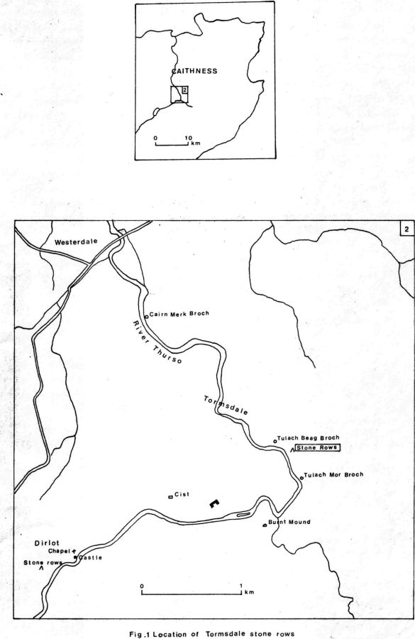
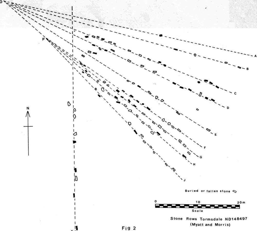
A SETTING OF STONE ROWS, TORMSDALE, CAITHNESS Leslie J. Myatt SUMMARY INTRODUCTION Perhaps the best known example of such a site in the north of Scotland is the setting of stone rows at Mid Clyth (NGR ND 258 384), known locally as the 'hill o' many stanes'. Although well documented elsewhere (RCHAMS 1911), (Thom 1971) this is only one of over twenty such sites which have now been identified. Other sites are not so easily accessible and are usual remote from good agricultural land which may account for their preservation. Typically, the stone rows comprise a number of upright stones firmly fixed in the ground and arranged in rows which radiate from one or more points. The stones are usually small and not more than 0.5m above the surface. Often they have become submerged by the depth of peat which has developed since the time they were set out. For this reason stone rows are not identified easily in many cases and may also be concealed by surface vegetatian, especially where there has been a considerable growth of heather. In Caithness, In particular, where the local rock is of flagstone, the stones are usually wide and thin, split along a natural plane, with the wide surface aligned along the row. A number of the settings of stone rows have been surveyed by Thom who has suggested a possible astronomical purpose for them (Thom 1971). Since his work was published a number of new sites have been identified in the north, mainly as a result of detailed archaeological survey work. Because of the insignificant nature of many of these sites, and the fact that the stones are often concealed beneath the surface they can easily be passed by unnoticed but further survey work may reveal yet further sites. THE TORMSDALE SITE The northern and western extremities of the site are bordered by an extensive area of peat where cutting has taken place in the past. Some of the stones are fallen and displaced in this part of the setting whilst others may have been removed. The surface In the region of the radiating centres of the fans comprises an area of hummocky peat which is slightly elevated above the remaining site. THE SURVEY From a computer analysis of the plan an attempt has been made to determine the orientation of the rows by calculating the best-fit straight lines through the centres of the stones. The problems associated with finding the intended orientation of the rows concern the accuracy with which the rows were set out originally and also the movement of individual stones which has taken place subsequently. There is no doubt that, unless the stones are firmly anchored to the rock surface below, movement does take place due to the effects of repeated freezing and thawing of the soil. This causes the stones to drift from their original positions. Such movement may not be the same for each stone and the magnitude and direction may be affected by factors such as the shape and size of the stone, its depth beneath the surface, and the slope of the ground. Any surrounding vegetation may also have a contributory effect. After plotting the calculated best-fit straight lines on the large scale plan there was a distinct indication of two radiating points for the rows. Rows A-E radiate from one point whilst rows F-J radiate from the other. These two points could not be determined precisely since there is a scatter of crossing points for the best-f it lines, albeit within a fairly small area. Row K does not coincide with the other rows near the radiating points and appears to be separate. A slight modification to some of the best-fit lines for the rows was made to make them coincident at one of the radiating points. This is shown in Fig. 2 where rows A-E and F-J radiate from points 0 and P respectively. The collections made are shown in Table 1 which gives the true azimuths of the rows as calculated and as modified to coincide at the radiating points.
TABLE 1 CONCLUSIONS Row H passes through both of the rotating points 0 and P of the two fan-shaped sectors, and the distance between these two points is 13.26m or 16MY, the megalithic unit of length established by Thom (Thom 1967, 34). The isolated row K has an azimuth which is due north and south. This is an interesting feature, and unlikely to be due to chance, since the same azimuthal indication is also found in the setting at Mid Clyth (Thom 1979, 91) where the central axis of the main fan is shown to be 358.5deg. At a number of other sites throughout Britain, including Callanish, Thom has found quite definite indications of the meridian (Thom 1967, 95). Since the horizon to the south of the Tormsdale setting is almost level, row K may have been set out by bisecting the angle between the two azimuths at the rising and setting of one of the fixed stars or the solstitial sun. It may also be significant that the tallest stones in the setting occur at the south end of row K. A further feature which is also found at Mid Clyth is the use of more than one fan-shaped sector radiating from separate points. ACKNOWLEDGEMENTS The author is most grateful to Mr. lnnes Miller, Dale farm, who gave permission to survey the site and who showed interest in the work. Thanks are also due to Mr. Charles Morris without whose help the survey could not have been carried out. REFERENCES
|
||||||||||||||||||||||||||||||||||||||||||||||||||||||||||||||||||||||