|
Caithness Field Club Bulletin |
|
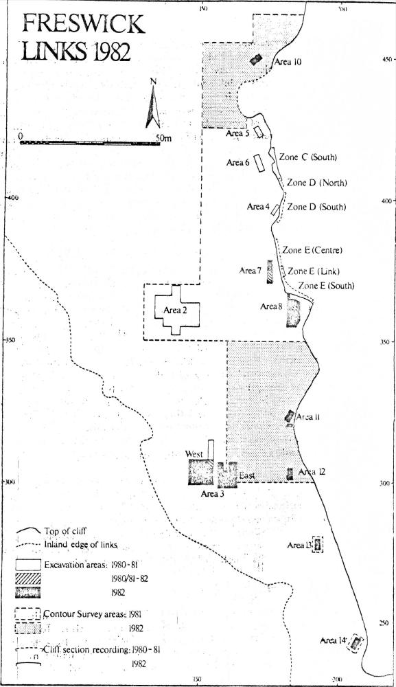
FRESWICK LINKS, CAITHNESS The fourth season of survey and third excavation season was undertaken at Freswick links in August and September 1982, with financial support from S. D. D. (Ancient Monuments) and Durham University, and assistance from the Community Services Agency, Caithness .1 Integral to the programme of work, as in previous years, was environmental survey and sampling and this largely governed the excavation strategy. However, as reported below, In Areas 7 and 8 sampling of the middens had to be somewhat amended because of the presence of structural remains.
A more detailed account of these results, together with those of the 1981 season, will shortly be available as a second Summary Report. SURVEY The contour survey work under the supervision of M. J. Rains continued to both south and north of the area previously covered adjacent to the cliff-edges, as part of a programme to link up the excavation areas. In 1982, a total of 2250m2 was contoured. Section recording: also under the supervision of M. J. Rains, approximately 11 m of eroding cliff section was drawn, once more showing separate dumps of midden. The section in Zone C, opposite excavation Area 6, linked up with sections drawn in 1980-1, and helped to establish the overall sequence at the coastal margin of the northern part of the site. A small second area was also drawn immediately opposite excavation Area 7, in Zone E, to 1 ink up two separate sections drawn in 1981. EXCAVATIONS 1. The Cliff Area Areas 11-14: Four trenches were established near to the coastal margins in the southern part of the site from Zones F to J. All the trenches produced clear evidence for a major midden layer, but it was particularly evident in Area 14 that this had been eroded in the past, leaving a heavily stone-laden deposit, as in Area 10. It appears that there is a decrease in the surviving amount of midden material from north to south, and Area 11 was most productive of the four in terms of artefactual material. In 1981, cultivation marks had been uncovered at the base of the excavations in Area 5, and were also noted in cliff section opposite Area 8. Perhaps the major discovery of 1982 was the presence, at a considerably lower level than the main midden deposits in the southern area trenches, of similar cultivation marks. These marks, in the basic and matrix, presumably represent the survival of only the earliest examples from this phase of activity on the site, and later marks may well have been obliterated by later regular cultivation. Little, if any, artefactual dating evidence was obtained, and excavation was severely limited by safety factors in small areas designed for examination of the middens as a higher level. In addition, indications of structural elements and other earlier archaeological contexts appeared in the bottom of two trenches. As, therefore, further investigation of earlier contexts below the middens would have to take place within larger areas, excavation was halted at arbitrary stages. Even so, Area 12 collapsed completely and only minimal recording was possible. Area 7: To accommodate examination of the structural remains revealed in 1981, the area was extended as a double-sized sample area of 8 x 2 m. Also, it is hoped to correlate information from the area excavated with that of the Zone E (Link) cliff section drawing approximately 1 m to the east. In the southern part of the trench a possible drain feature had been partially examined in 1981, but further examination showed it to be poorly constructed and such an interpretation must remain in question. In the north extension, below sand overburden, a very dark clayey midden deposit, rich in fish, mammal bones and stone, was excavated, and similar in character to layers to the south. Beneath this midden and dune sand, a substantial stone feature, possibly a drain aligned east-west, was located. A wall line nearby, also beneath the midden deposit, on a slightly different alignment was stratigraphically higher than the drain, and probably from a different structure. Two stones in the north section of the trench and others in the west, could however be related to the drain. The indications are that this trench has been cut across a byre, and therefore work was halted at this stage, pending larger-scale area excavation of the whole structure at a later date. Environmental Sampling Area 8: This area was initially examined In 1981 as a 4 x 2 m sample area, and located structural remains. In 1982, it was extended to 5 x 10 m and realigned onto the main site grid, set back from the actual cliff edge. A series of four water-worn boulders were visible on the surface and suspected to be an extension of the wall line of single boulders noted in 1981. However, they proved to be superficial and south of the termination of the 1981 wall line. All midden-like layers and sandblows dipped below this wall which also extended northwards for approximately 2 m (although it did not show in the exposed cliff section a further metre to the north). It was interesting to note that the wall line provided a division between later midden layers to the east and earlier ones to the west. The wall line ended abruptly at its southern end, and it seemed possible that it had been robbed out. A small ditch, possibly for drainage, running along the east side of the wall, was cut into deposits predating the wall, and itself terminated exactly with the wall - its significance cannot be judged at this stage. In the extreme north-east corner of the trench, very rich peat ash deposits produced extensive traces of carbonised seeds, predominantly oats with barley. Environmental Work: In 1981, sampling within the system for sample areas was undertaken, and this was extended for the larger area in 1982, However, the complicated horizontal stratigraphical relationships and presence of structural remains necessitated modifications to the system in this area. In the end a 4 x 0.50 m strip along the western margin of the area was sampled, and in the north-west corner, extended to the cliff face where a complete column sample through 3 m of deposits, including rich middens, was obtained. 2. Inland Areas of Erosion In 1982, two adjacent areas were opened here, west and east. Area 3 west was a tongue of upstanding grassed land surrounded by the wind-eroded blow-out of Zone Q. An area of 9 m2 was initially examined incorporating the southern part of the original Area 3 examined in 1980, which produced a cist grave. A series of mixed sands and sand-blows were located containing fragments of industrial residue and abraded pottery. The area was in addition badly disturbed by both rabbits and cattle. Structural traces were confined to a line of stones, probably vestigial, which now lack associations. A curving linear feature was located below the upper sand blows, which was filled partially with a peaty deposit. There were apparently no further features remaining in association with this. The area to the east (Area 3 east) was opened partially over a grass-covered stony mound and eroded patches, as it seemed potentially more productive and less disturbed. The mound was an area of stones set roughly in an arc in the part examined, with middeny deposits largely confined to the south of it. Most of the rest of the trench was unproductive (except for a single find of a complete bronze pin) and excavation therefore limited. However, in a trial trench within this area, a charcoal-rich deposit was revealed in the north-west corner at a considerably lower level. Again further examination would require large-scale area excavation, and resources did not allow further investigation of it this year. Environmental Work: Throughout this excavation, as with Area 2 in previous years, areas and particular contexts were sampled as seemed appropriate, but not to the level of the work in the cliff areas. In particular, the midden deposits of the mound, and the early charcoal deposit were extensively sampled. In association with this work, Dr. Smith carried out a programme of augering to examine midden deposits in the inland areas of the site, following up the work of 1979. CONCLUSION 1 . Archaeological Reports for 1981, 54-58 |