| Caithness.Org | Community | Business | Entertainment | Caithness... | Tourist Info | Site Map |
• Advertising • Chat Room • Contact Us • Kids Links • Links • Messageboard • News - Local & Scottish • News - UK & News Links • About / Contact Us • Submissions |
• Bookshop • Business Index & News • Jobs • Property For Sale • Property For Rent • Shop • Sutherland Business Index |
• Fishing • Fun Stuff • George, The Saga • Horses • Local Galas • Music • Pub Guide • Sport Index • What's On In Caithness |
• General Information • B & Bs • Backpackers • Caravan & Camping • Ferries • Getting Here • Holiday Letting • Hotels • Orkney • Pentland Firth • Sutherland • Taxis |
| N E W S F E E D S >>> |
|
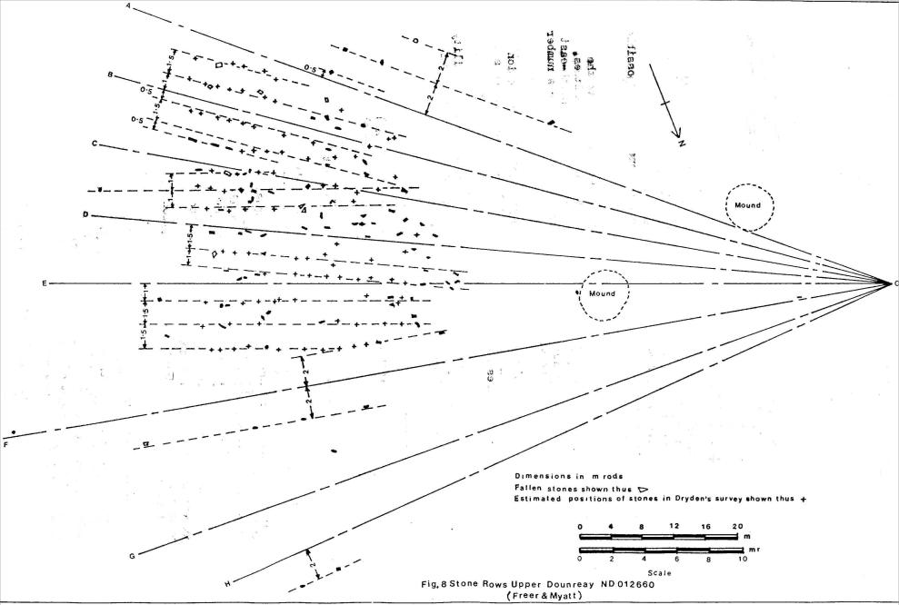
CAITHNESS FIELD CLUB BULLETIN vol. 3 No. 5 April 1983 THE MULTIPLE STONE ROWS OF CAITHNESS AND SUTHERLAND This article is a continuation of the description of the settings of multiple stone rows which was commenced in a previous edition of the Bulletin (Freer and Myatt, 1982, 58). 11. Upper Dounreay I ND012660 The stone rows are situated in a hollow 60Om to the north-west of the two long cairns of Cnoc Freiceadain and Na Tri Shean (Henshall 1963, 267, 282). They are in an area which is quite rich in antiquities of the neolithic period. There is the short horned cairn of Upper Dounreay to the west of the rows (Henshall 1963, 298) and beyond it a standing stone 2m high. To the south-east is a cairn having set around it eight small stones which may be part of an elliptical setting. There is also possible evidence of a neolithic quarry (Myatt 1977, 46).
The suggested geometrical construction on the plan shows radial lines similar to those at Garrywhin, again with rows of stones parallel to them. In the centre of the site the sets of lines overlap and some have been omitted from the diagram for clarity. The inclinations of the radial lines to the assumed axis OE are given in Table 4.
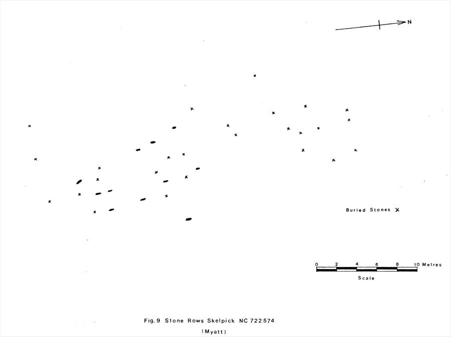
TABLE 4 On the higher ground to the west of the rows, but within the geometrical construction, are two low grass-covered mounds. Any astronomical observation from this site could possibly have been of the moon rising in its extreme northerly position which would be just visible over the island of Hoy, Orkney. 12. Upper Dounreay II ND007660 Nothing is known of this setting of stone rows. It is shown as a 'site of' stone rows on the 1:10000 O.S. map, 500m to the west of Upper Dounreay I. Since the map also shows field drains in this area, there is a possibility that the stone rows may have been removed at the time the drains were laid. 13. Skelpick NC722574 This setting of stones, first recorded by Myatt (1975,55), was destroyed in 1982. The results of a hurried survey carried out in 1975 are shown in figure 9. A total of eleven small stones were to be seen protruding above the surface, the tallest not more than 20cm high. Exploring the surface with a probe revealed the positions of other possible stones shown on the plan.
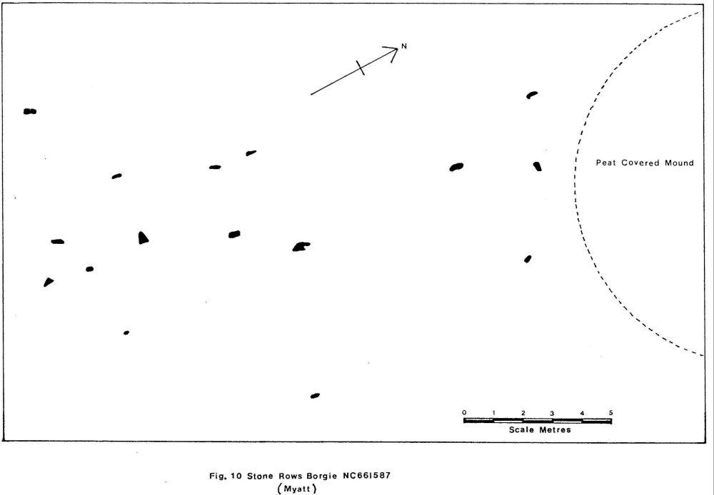
No attempt has been made to superimpose a geometrical construction on the plan because of the uncertainty of the positions of the buried stones, although the pattern does suggest that there may be parallel rows. That this site had been destroyed merely emphasises the vulnerability of this type of monument. The number of such sites to be found today may be only a fraction of those originally set out. 14. Borgie NG661587 Stone rows were first recorded (Ordnance Survey 1978, 46) at this location as a result of survey work carried out by the Archaeology Branch of the Ordnance Survey.
The setting is on sloping ground near to the Bettyhill-Tongue road (A836). Unfortunately there has been extensive peat cutting in the area and a total of only sixteen stones now remain to the north of a small stream Allt Loch Tuirslighe. The ground slopes upwards to the north east at which end is a low peat-covered mound with no visible features. The stones are rounded boulders of local stone, the tallest being about 20cm above the surface, and all are firmly set in the ground. Because of the small number of stones and their distribution no geometrical construction is suggested on the plan. If they were originally set out in rows their alignment was possibly approximately north-east and south-west. 15. Loch Rimsdale NC716348 Members of Glasgow University Archaeological Society first recorded this site (Gourlay 1975, 7) to the west of Loch Rimsdale whilst undertaking field work in the latter part of 1975. A survey wag carried out because the area was in imminent danger of archaeological destruction by deep ploughing for the Forestry Commission. The rows lie almost hidden on the saddle of Cnoc Bad na Fainne and in the immediate vicinity is a standing stone with its flat axis directed towards Morven prominent on the horizon almost 30km away.
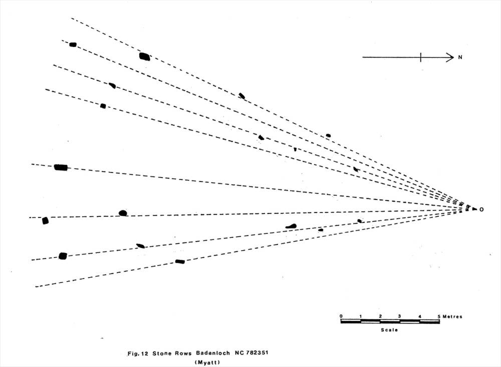
Situated symmetrically about the main axis of the setting and towards the centre of the sector is a small mound of about 6m diameter. Although it has the appearance of a field clearance cairn, its purpose could be otherwise. 16. Badanloch NC782351 On ground rising gradually towards the top of Cnoc Molach, and 0.5km from the shore of Loch Badanloch, is a setting of 18 small stones in a fan- shaped array. The largest stones, of which the tallest is 62cm, stand at the base of the fan and the ground slopes upwards towards its centre. This site which is about 6.5km east of that at Loch Rimsdale was first recorded (Ordnance Survey 1977, 49) by the Archaeology division of the Ordnance Survey.
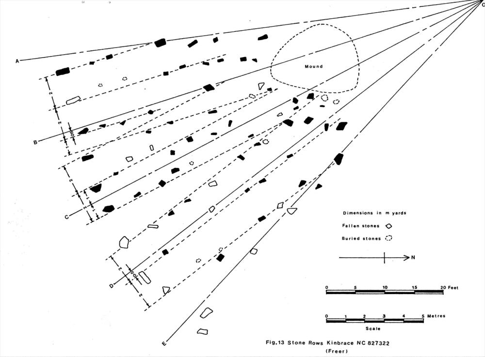
In the vicinity at NC781356 is evidence of a burnt mound, and also a probable cairn at NC782353. 17. Kinbrace NC827322 This group of stones, first reported by Myatt (1975, 54), is near to the ruined chapel site and burial ground at Ach' na h-Uai' north of the B871 road. They are set in rough ground on a slight slope overlooking the river Helmsdale to the south.
The inclinations of the radial lines to the assumed axis OC are given in table 5. TABLE 5
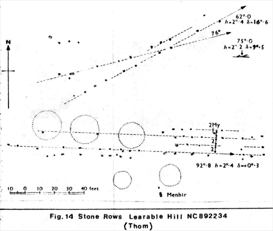
All the stones are small rounded boulders of local stone with noticeably taller stones at the south-east ends of the rows. The ground rises slightly to the centre of the fan at 0, and immediately adjacent to the rows at the north-west end is a small low mound. It is peat covered and roughly circular in plan. In the vicinity of this site are the remains of chambered cairns, hut circles and old field boundaries. Running close to the outer circumference of the fan is the track of an old road. The modern road runs 300m to the south of this. Investigating the possibility of astronomical alignments at this site, it was observed that the radial line OE indicates the direction of a notch formed between the slopes of An Cnoc Buidhe and Eldrable Hill at the southern end of Strath Kildonan. When the moon rises at its extreme southerly position it would be seen to be just touching this notch by an observer looking along the line OE. 18. Learable Hill NC892234 In the Strath of Kildonan, to the west of the River Helmsdale near Suisgill Lodge, and below the summit of Learable Hill are numerous rows of small stones crossing over the hill. Set with their broad faces in the line of the direction of the rows, they are of local stone varying in height above the surface from 30cm to 60cm. Near to the rows is a single standing stone 1.6m high inscribed with a plain Christian cross. Numerous small peat-covered mounds, some of which are across the rows, scatter the area. To the west of the site the ground rises gradually, but to the east it falls fairly steeply and, in the distance, the horizon exhibits the quite distinct peaks of the far hills on the skyline.
Evidence has been shown (Thom 1967, 110) for the possible use by the megalith builders of a sixteen month calendar with either 22 or 23 days in each month. Indication of significant calendar days are found from the alignments of stones. These give the position of sunrise or sunset along the horizon at the beginning of each month, and similar directions have been found at a number of different sites. In the calendar suggested by Thom, the directions of the rows shown in Figure 14 is significant in that the alignments are such that they would indicate the position of the rising sun on three of three calendar dates. The row having an azimuth of 62o.0 would indicate the position of the rising sun at the beginning of May at about the time of the Celtic festival of Beltaine. Using our present calendar the sun would rise along the direction of this row on 6 May. Towards the end of August, on the 29th using our present calendar, the sun would rise along the row having an azimuth of 75o.0; and the alignment of the parallel rows is such that they would indicate the position of the rising sun at the equinoxes. 19. Kildonan NC955185 The inventory of ancient monuments in Sutherland (RCAHMS 1911,133) describes stone rows at Allt Breac on the south side of the road leading up the Strath of Kildonan. A plan shows about 14 fan-shaped rows close to the side of the road. On the opposite side of the road are two large cairns. A recent search (1982) in this area did not reveal the existence of this site. There is now a layby at this point on the south side of the road and possibly the stones have either been buried or removed. 20. Kildonan NC966189 A further site described in the Sutherland inventory (RCAHMS 1911, 132) is the setting of stone rows at Torrish Burn. The two rows of stones as shown in the survey of Figure 15 consist of fairly large boulders set in the ground rising steeply to the west near the top of a natural hillock. Surmounting the hillock is a low rectangular-shaped mound approximately 8m x 4m which has a number of small stones protruding around its periphery. The tallest of the stones is 52cm high and the two rows converge slightly as they run down the slope to the east. From their appearance it is not certain that these rows form part of the same class of monument as the other sites described. A New Caithness Site Since the preparation of this article, a new site has been recorded, by the Archaeology Division of the Ordnance Survey, in Caithness at Tormsdale. Once an accurate large scale survey of this site, which is quite extensive, has been carried out, it will be described in a future edition of the Bulletin. Acknowledgement 1 . The authors gratefully acknowledge permission given by Oxford University Press to reproduce Figure 14. R E F E R E N C E S Freer, R. & The Multiple Stone Rows of Caithness G.F.C. Bull. 1982 Myatt, L.J. and Sutherland 2 Vol.3 No.3 Gourlay, R. A Field Survey in the Loch Rimsdale Area Glasgow 1975 Henshall, A.S. The Chambered Tombs of Scotland Vol.1 Edinburgh 1963 Myatt, L.J. Discovery & Excavation in Scotland SRGA 1975 Myatt, L.J. Two Possible Prehistoric Quarries in C.F.C. Bull. 1977 Caithness Vol.2 No.1 Ordnance Survey Discovery & Excavation in Scotland SRGA 1977 Ordnance Survey Discovery & Excavation in Scotland SRGA 1978 RCAHMS Second Report and Inventory of Edinburgh 1911 Monuments and Constructions in the HMSO County of Sutherland Thom, A. Megalithic Sites in Britain Oxford 1967 | ||||||||||||||||||||||||