|
Two Ancient Worlds - The Moon &
The Northern Highlands of Scotland Some unexpected results of contemporary research in the rapidly expanding study of the early history of the Earth as revealed by the application of space technology (PLANETARY GEOLOGY). In the 35 years following the second world war the art of rocketry rapidly advanced to become a useful scientific tool, with knowledge and technical expertise progressing side by side as uneasily enforced partners during the course of the "space race" between America and Russia. From the late nineteen forties through to the economies of the seventies the story was a continuous one, beginning with research in the upper atmosphere moving up to orbiting space satellites, and culminating in the manned Moon landings of Apollo 11 to 17. The late seventies saw unmanned probes sending back pictures and data from Mercury, Venus, Mars, Jupiter and Saturn, not to mention the amazing moons of the last two. Information from the Voyager mission should continue to be received till the mid eighties, and there is always the projected fly past (and possible landing) on comets Halley and Tempel-2 in 1985 and 1988-89, thus as the results have become available for comparison a new picture of the common history of the Earth and her nearest neighbours has begun tentatively to emerge. In this way nearly 40 years worth of accumulated information gleaned from these historic but expensive research efforts is beginning to be pieced together to give some insights into past events in the development of the Earth itself, and not always in ways that could have been foreseen in 1945.
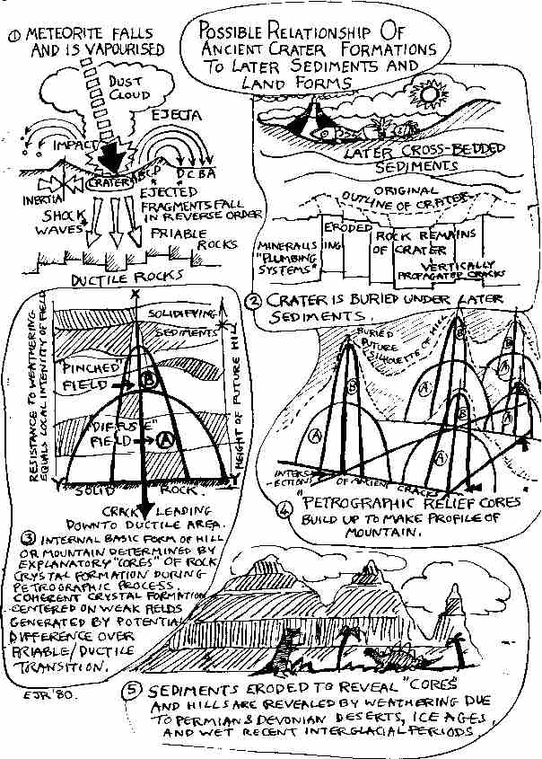
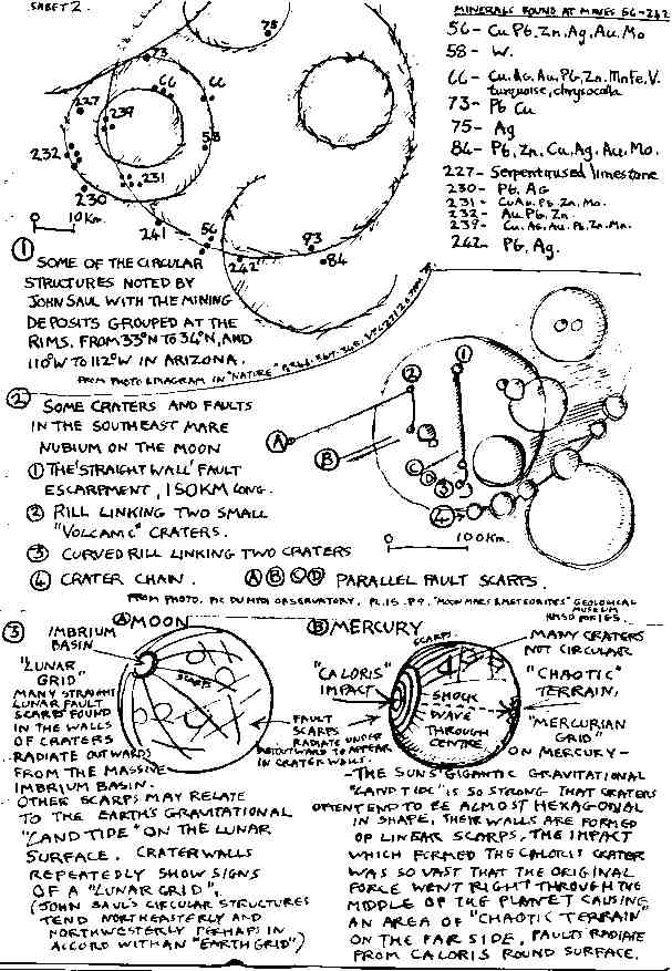
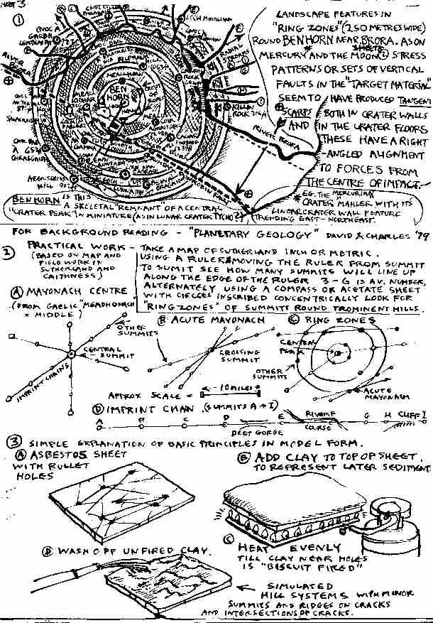
Automatic satellites are monitoring the Earth's weather, the ocean depths have been surveyed from space stations such as Skylab, as varying vantage points in orbits above the Earth enable patterns to be recorded that are invisible to a ground based observer. Infra-red cameras detect minute variations in vegetation cover and temperature which reveal traces of land use, mineral deposits, or diseased crops, and it is possible to take a global view of climatic and geological systems which previously was possible only in theory. The influence on the weather of the "solar wind" of electrically charged particles continuously discharged by the sun across what was once thought to be the empty vacuum of space is a discovery which has come as a direct result of space born instrumentation. The Earth and the planets are now known to be surrounded by radiation belts such as the Earth's "Van Allen" belts, and all of these scientific "spin-offs" of space exploration are leading to the restructuring of many ideas as to the past evolution of the Earth and the solar system. A recent result of the detailed analysis of the several hundred Kg. of rock samples brought back from the Moon's surface, has been the establishment of a sequence of events in the far geological past, which have caused the familiar pockmarked lunar surface with its circular craters. These periods are named after prominent lunar landmarks or features thought to be contemporary with them. There are three of these and they comprise, firstly the "Imbrian" at 4,000 million years ago and named after the Mare Imbrium a lava-filled impact basin 1,00OKm in diameter, and secondly and thirdly the "Eratosthenian" at 2,000 My and the "Copernican" at 1,000My which are named after the craters Eratosthenes and Copernicus. Geological timescales tend to be so vast as to be meaningless (and can be devalued by fashion) so that it is more relevant to say that the Imbrian was taking place as the first oceans were beginning to form, the Eratosthenian accompanied the earliest cellular life-forms, and the late Copernican was contemporary with the first appearance of living creatures in the fossil record of the dawn of the Cambrian period on Earth. Each of these periods of events is considered to have consisted of successive phases of intermittent or intensive bombardment of the Moon by meteorites, the earliest being the most violent and prolonged in a series of far-reaching geological shake-ups in which matter (in the form of massive rocks left over from the formation of the solar system) impacted with the Moon's surface at speeds of tens of kilometres per second. It is concluded that the Earth and Mars as well as Mercury and the moons of Jupiter and Saturn, (not enough is known of the surface of Venus) were all affected in a like manner during the same or similar periods. Some of the last major impacts or crater forming events on the Moon (during the Copernican period of up to 1,000My) were taking place during the epoch known as the Proterozoic in contemporary Earth geology, a period which saw the last general upwelling of the ultra deep level mineral called "Anorthosite", a mineral which has not found its way to the surface since then, but which is found in lava flows on the Moon which are associated with rupturing of the lunar surface due to massive deep impact damage by meteorites. This period also spanned the ages during which the sediments were deposited which (after a phase of heat or metamorphosis some 500My later) were to became the Moine schist series of shield rocks which form so much of the west and north of Scotland and which underly the Caithness flagstone (old red sandstone) series. The weathering caused by the Earth's water and atmosphere has all but erased the actual craters which must have studded the land surfaces of the youthful planet. Recent research has however begun to produce results which confirm that these ancient impacts had a direct and far reaching effect on the terrestrial shield areas of which the north of Scotland is one. One important aspect of these ancient shield areas with their crystalline metamorphic rocks is the presence there of extensive mineral deposits, and in every part of the world where these rocks are to be found they are the subject of close scrutiny by geologists and mineralogists in the employ of commercial mining enterprises. During these surveys detailed 3-D relief maps are made as part of the routine process of investigating different geographical sectors. The geological structure of the area under consideration is more vividly displayed when the vertical factor in the map is increased by two to give double the effect of height. These maps have been found to exhibit many interlocking circular structures when photographed or viewed in oblique light. The mineralogist John Saul ("Nature" Vol. 271; 26.1.78; P. 345) has charted many hundreds of these relict structures and noted that numerous mining sites based on mineral deposits lie at overlapping junctions of circle rims. This is because the deeply sited original sources of the mineralising fluids below have had access to the surface (where the minerals have crystallized) by means of vertical faulted or fissured "plumbing systems that have taken the place of the fractured crater rim. (Residents in Sutherland will be interested to note that the gold deposits at Kildonan are to be found in a ring of gold bearing streams leading in from a roughly circular "zone" round the area of Kildonan, but also outwards away from Kildonan if the streams rise on the other side of the watershed zone where the deposits originate.) These structures are not thought of as the physical remains of actual craters but more like "after-images" comprised of ridges, hills, river channels, lakes, cliffs and valleys, which have subsequently appeared during earth movements on the site of the original crater limits but in much later sediments overlying or replacing the ancient fractures. The circular structures like the lunar craters are often many hundreds of kilometres in diameter, in fact the "Vredevoort Ring" in South Africa has been calculated to be the outcome of the collision with the Earth of an asteroid or very large meteorite, the dimensions of which would make it at least as vast as a Himalayan sized mountain, and which is thought to have had an impact mass of some thirty thousand million tonnes! In a nuclear age it is more than a little off-putting to discover that the Earth has weathered many such impacts in which most of the mass of both meteorite and the rock excavated to form the crater, would be explosively vapourized on contact, and yet the physics involved (in which the kinetic energy is totally turned to heat) would not have troubled Isaac Newton. While the scale of both the rings and the means with which they were created, tend to dwarf human explosions, they are not out of line with similar estimates for the Moon's larger craters, and would make even something like the Gulf of Mexico a ready candidate for interpretation as a terrestrial "lunar style feature". Landform structure is visibly character- ised by the repetition of two basic types of shapes, one circular or oval in the form of island arcs and bays, and the other linear in the form of fault boundaries and rifts. The Earth's surface moves sideways or vertically along faults and rifts and sinks or rises in the rounded forms of geo-synclines and anticlines (the last of which are important to the oil industry as they form dome-like traps undergrounds for oil). The rifts seem to be connected with the "land tide" which the Moon causes by means of its gravity, and the slow rise and fall of the basin-like structures to be linked to convection currents beneath the Earth's crust. However, the newly formed science of "Impact Geology" may be able to provide links to the two families of geological forms. The level of contact between the solid crust of the Earth and the semi-liquid rocks beneath is marked by an interface known as the "ductile-friable transition", at present 2.5 - 4 kilometres beneath the surface (in the past this may not have been so deep). The explosive impact of a body of rock ranging in size from a "battleship" scaled meteorite to a medium "mountain" sized asteroid, moving at a speed of several Km/Sec would send radial fractures out from the central impact point as well as creating rings of "shock-wave" tangential fractures as the outward impetus of the explosion reacts with the inertia of the surrounding crust in concentric circle formation centred on the initial point of vapourisation. Just such "ring fractures" are clearly marked on several of the Voyager pictures of the moons of Jupiter. One in particular, of Callisto, shows a dramatic crater with concentric rings reaching nearly halfway round a world one third bigger than the Earth's Moon. On Earth these fractures would reach down to the ductile-friable transition, and thereafter become self perpetuating as the soft rocks of the lower ductile area through time solidify to become friable (brittle) rocks in their turn, and the fracture imprint is propagated downwards. The Earth is distinguished from its companion worlds Mars, Venus and Mercury by the presence of large masses of water on its surface, as well as in its atmosphere. Though the earlier most intensive bombardments took place when terrestrial volcanic action was beginning to create both water and atmosphere, the later more sporadic events must have triggered off chain reactions composed of rapid shifts in sea floor level, volcanic eruptions, and land movements, as the Earth had acquired both its seas and its land (and also an actively mobile continental crust). Both on land and in the sea, life in its early stages must have seen rapid changes in environment as syncline changed to anticline and land rose and fell due to intermittent but massive shocks to the crust. The sudden excavation of even a medium sized 3OKm diameter crater anywhere in the vicinity of the shallow inland seas, such as at a later date - "lake Orcadie", would cause extensive tidal waves with resultant deposits of mud over the surrounding area covering hundreds of square kilometres. Dust slowly falling back through the air to the deserts and water basins, would form blanket-like but finer bands of sediment, interspersed with mud deposits and volcanic ash layers in the banded strata that are so characteristic of ancient rocks. The many thousands of feet of these early sediments could have thus been created by a combination of sporadic but overwhelming impact forces in conjunction with the routine sandstorms, flash floods, and massive tides of the youthful planet itself. The case of the "Iridium" layer which has recently been noted by independent observers both in sea-bed sediments and in rocks on land in many parts of the world, and universally dated to 65 million years ago, is increasingly being attributed to a single massive meteorite on the scale of the Vredevoort Ring impact. This global 1 cm layer of clay is found at a level corresponding to the Cretaceous-Tertiary boundary and exactly contemporary with the widespread extinction of the Dinosaurs and many other species. The calculations involved in the prediction of the size of meteorite required to produce the energy for such an event involve fitting the mass and speed of the meteorite or asteroid into the "simple" kinetic energy equation E = 1/2MV2 (V=velocity) so that with no newfangled nuclear energy involved, an asteroid 10Km in diameter (for instance one of the Apollo group whose orbits cross that of the Earth) moving at between 30 and 40 Km/sec would create an impact crater 175Km across and spread pulverised rock dust into the stratosphere to settle as a thin layer across the surface of the Earth (New Scientist 10 Jan. and 6 March 1980).The kinetic energy having been converted into heat at the moment of impact, the explosive power created is thus estimated at 100 millions megatonnes of TNT which if the event happened at sea, would be sufficient to vapourise 16000 cu. km of water which is enough to provide 2cm of rainfall over the entire Earth. Iridium is considered to be an extra-terrestrial mineral and is found both in meteorites and on the Moon, so that the lcm clay layer noted above must have come in considerable quantities from outside the Earth at that time. The surface of the Moon outside its mountain areas has been verified as a 50m dust layer overlaying a deeply cracked and faulted hard rock sub- surface with the faults often showing up as straight line features criss- crossing the dusty surface. These features are known as "rills" when found singly, "horsts and graben" when parallel, and as "sinuous rills" when linked in zig-zag combinations. Frequently the rills are lined with craters and often end in craters or domes of solidified lava. These small craters are not thought to be impact originated but to be caused by volcanic explosions released from within the surface as the fault or crack spread. Other linear features are rows of minor craters (or craterlets) centred on major impact craters and thought to be caused by fragments ejected from the primary impact or, once again, to be of volcanic origin and caused by explosions along radial cracks spreading out from the impact centre itself. The lack of water and air on the Moon has preserved many of these fragile sandy forms since their creation. On the Earth however they were buried under many thousands of feet of sediments which covered the hard cracked rock surface with its counterparts of the rills, lava domes, craters and crater chains of the lunar surface. Later the whole mass turned to stone, was metamorphosed and then eroded, but the impact forms were not destroyed, in fact they re-emerged altered into repetitive landscape features found everywhere in Highland scenery and may well underlie topographic elements all over the world. Accordingly the quickest way to verify whether there are traces of concentric or radial linear patterning (such as should be detectable as the hallmark of an ancient impacted area), always supposing that any such patterns have not been blurred out of existence by later geological events, would be to fit the co-ordinates of all accurately mapped geological features in selected areas of the N. W. Highlands into a computer programme, and after a suitably specific set of characteristics have been isolated, print out those sets of co-ordinates which conform to interpretation as linear features and also to determine graphically what patterns emerge. The only features plotted accurately enough by the (H.M.) Ordnance Survey theoretically to provide an instant check if such a simple programme were to be run through a computer, are the spot heights of hill summits end road high points, so that if these clearly defined positions are analysed together with other points such as the tips of sharp promontories and the positions of fault generated features such as waterfalls, edges of steep cliffs etc. then it might be possible to pin-point any recurrent "tell-tale" left-over imprints of shock patterning that may have survived. Short of having a computer to "join up the dots" it is just as much fun to use the human eye and a ruler to try to determine what if any regular features can be determined in any section of a O.S. map of the northern Highlands. That such features do quite clearly display themselves if such a systematic search is carried out is the subject of the last part of this article. It is hoped that the previous paragraphs will form a rough guide to a new and quickly expanding subject that will no doubt continue to produce interesting and unexpected results. The presence of straight line hill summit systems with great numbers of examples in the Moine schist and Helmsdale granite hills of Northern Sutherland was noted by the writer in 1976 (Caithness Field Club Bulletin Vol. 1 No. 8) though the systems came to light through an independent investigation of the relationship of iron-age brochs to the structure of the surrounding terrain (if the brochs were to function as signal stations as recorded in local tradition). Finally here are some specific terms to define the forms under discussion. 1 "Imprint Chain" 2. "Mayonach Centre" (from Gaelic "Meadhonach" = "Middle") An "Acute" Mayonach - these are found in rings concentrically round some Mayonach Centres and seem to have their origin in tangential or chord formations produced by such waves and perhaps underlying ancient crater rims. 3. "Petrification Relief Core" |