

 | Caithness.Org | Community | Business | Entertainment | Caithness... | Tourist Info | Site Map |
• Advertising • Chat Room • Contact Us • Kids Links • Links • Messageboard • News - Local & Scottish • News - UK & News Links • About / Contact Us • Submissions |
• Bookshop • Business Index & News • Jobs • Property For Sale • Property For Rent • Shop • Sutherland Business Index |
• Fishing • Fun Stuff • George, The Saga • Horses • Local Galas • Music • Pub Guide • Sport Index • What's On In Caithness |
• General Information • B & Bs • Backpackers • Caravan & Camping • Ferries • Getting Here • Holiday Letting • Hotels • Orkney • Pentland Firth • Sutherland • Taxis |
| N E W S F E E D S >>> |
Caithness Field Club Bulletin
1982 - April
|
The Multiple Stone Rows Of Caithness
& Sutherland Of the known settings of stone rows in the north of Scotland plans of accurate surveys have been published of only about a third of them. Most of these are the results of the work done by Professor Thom. It intended in this article, and the following one, to give a description of the sites with available plans including those of Thom together with the results of recent surveys carried out by the authors which have not been published recently. From an analysis of the diameters of circular stone settings, obtained by accurate survey. Thom (1967, 34) concludes that a standard unit of length equal to 0.829m was used in setting out the diameters. This unit he names the megalithic yard (my) and further claims that the same unit of measurement was in use throughout Scotland, England, Wales and Brittany. He demonstrates its use in the construction of stone rings which are not true circles and also the multiple stone rows. Furthermore it is claimed that a multiple of 2.5 times the megalithic yard was also used. This Thom names the megalithic rod (mr). An attempt is made in the following description of the settings of stone rows to bring together all the known sites with the results of accurate surveys where available and to see what similarities exist. Whereas a number of sites have been previously described in the RCAHM-S inventories some of the more recent discoveries have been given little or no account in print. 1. Mid Clyth ND 295384 Rising to the top of a small south-sloping hill each of the stones in the setting is clearly visible above the surface. There remain some 23 rows of stores set out in fan-shaped arrays with a central axis running along the slope and almost due north and south. The stones are mostly thin slabs of local stone set with their long axes along the rows. The largest is about 4m high, lm wide and 0.4.m thick whilst others are much smaller. Each is firmly wedged at its base with smaller stones.
Figure 1 shows the plan as drawn by Thom (1972,92) in which he demonstrates that the stones could have been set out on a grid of radial lines and uniformly spaced arcs forming three separate but inter-related fans. The main fan has a length of 43.5m, is 40m along the base and set out with a radius of 110m. Immediately adjacent to the main sector and to the west are two conjoined fans of smaller extent. To the east of the main sector are a few other rows of stones which Thom (1971,92) suggests may be taken to indicate that there were annexes symmetrical with those on the west. Atkinson (1981, 206) however states that the surviving evidence on the ground gives little support for this hypothesis, and it would be surprising if such an eastern annex had been almost totally destroyed, whilst much still remains of the adjacent eastern part of the main rows. Although not all the stones still in existence appear to be shown in Figure 1, it indicates the positions of nearly 180 stones. An earlier, but less accurate,, plan drawn by Sir Henry Dryden in 1871 indicates a total of 250 stones. This plan is now preserved in the library of the Society of Antiquaries, of Scotland. From the base of the fans to the most northerly radial centre is a distance of about 125m which would place the centre of the are beyond the top of the hill, and out of sight from most of the stones. This would have presented some slight, although not necessarily insurmountable, problems in setting out the rows, if they are geometrically as Thom suggests. In commenting upon Thom's plan of this site Burl (1976, 158) casts doubt upon whether the rows were originally set out as precisely as he suggests. Whilst accepting that some of the stones may have been displaced due to solifluction, Burl points out that only 290% of the stones actually lie on the supposed grid and that 41% are in positions which are up to 0.6m away from it. 2. Loch Watenan ND318441 3. Watenan ND315412 Not more than three stones now stand in any one row. The rows are fan-shaped, tapering towards the northern end with the main axis aligned a few degrees to the east of true north-east.
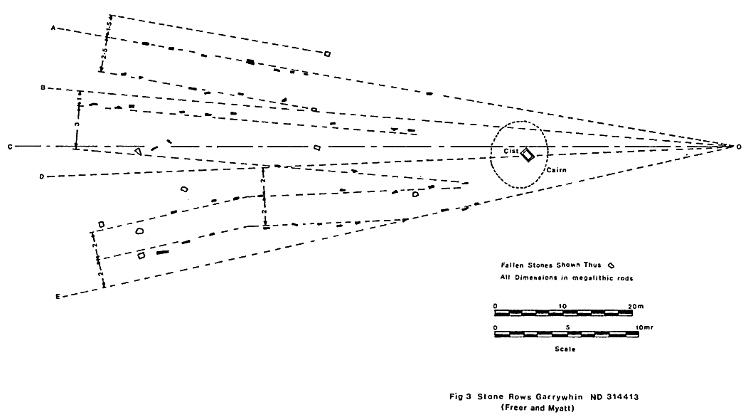
4. Broughwhin I ND313412 5. Broughwhin II ND312409 Some 55m to the west of this setting is a single row of 5 upright small stones aligned along the top of a ridge. 6. Broughwhin III ND311408 The rows are aligned approximately south-south east and north-north west with 10 stones in the row to the west extending over a distance of 34m, and 3 in the other row, extending over a distance of 24m. 7 Garrywhin ND314413 The stone rows radiate to the south of a cisted cairn which was excavated by Dr. Joseph Anderson in 1865. Within the cist were found "fragments of an urn of twisted string ornamentation" which would probably be dateable to the early bronze age period. Amongst the pottery were found two human molars and from the clay base of the cist two oval-shaped pieces of chipped flint. A survey of the rows was made by Sir Henry Dryden in 1871. This survey is preserved in the library of the Society of Antiquaries of Scotland but has not been carried out with the standard of accuracy as the surveys of Professor Thom. It is reproduced in Anderson (1886, 126) and more recently in Hadingham (1975, 126). It shows a total of 46 stones arranged in 6 rows. The RCAHM-S inventory of Caithness indicates 8 rows with a total of 37 stones. A comparison of the above accounts of the setting is given In Table 1 counting the rows from the east. |
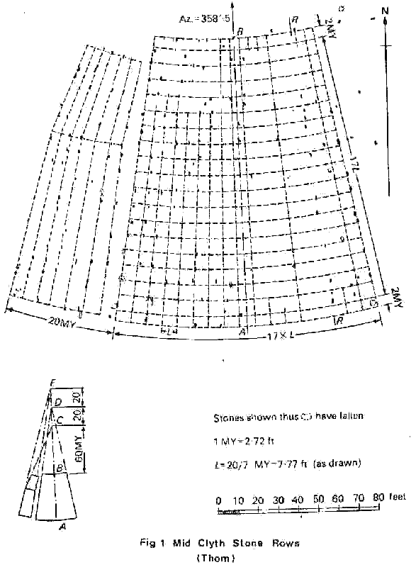
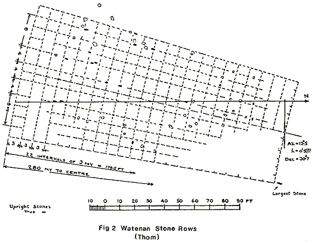
TABLE 1
|
ROW |
1 |
2 |
3 |
4 |
5 |
6 |
7 |
8 |
Total |
|
Stones (Anderson) |
11 |
8 |
3 |
9 |
8 |
7 |
- |
- |
46 |
|
Stones (RCAHM-S) |
10 |
3 |
4 |
1 |
1 |
8 |
5 |
5 |
37 |
|
An accurate survey carried out by the authors in 1981 is reproduced in Figure 3. It shows a total of 55 stones of which 47 are still standing and 8 fallen. Superimposed on the survey is a geometrical pattern which may have been used to set out the rows. The pattern has the following features: The axis is assumed to lie along the line OC and the radial lines OA, OB, OD and OE are drawn at right angles inclined to the axis as shown in Table 2. These angles were chosen because they are the same as those already measured (Freer and Quinio, 1977,52) in the similar multiple stone rows at Kerlescan in Brittany. The stones lie either on the radial lines or on lines parallel to them. Four sets of parallel lines can be identified. The spacing between the outer lines of each set is 4 megalithic rods. |
TABLE 2
|
Radial line |
OA |
OB |
OC |
OD |
OE |
|
Inclination to axis |
9deg. 48' |
4deg. 52' |
Axis |
2deg. 25' |
12deg. 16' |
|
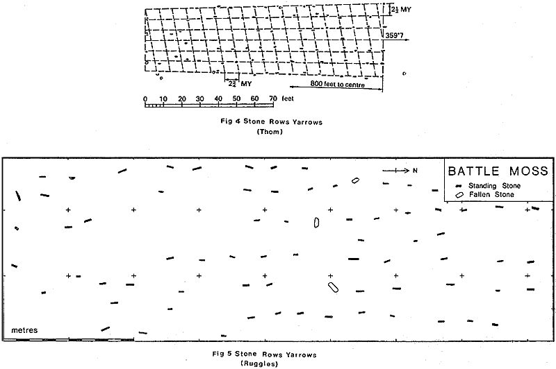
The cairn and its burial cist are situated at the top of a hillock down which the rows radiate to their base in a south-south westerly direction. As in the case of Mid Clyth the centre, 0, of the fan-shaped sector is not visible from the stones in the rows since it is beyond the top of the hillock. Prom the cairn it is possible on a clear day to see the hills of Banffshire some 80km away on the other side of the Moray Firth.8. Loch of Yarrows ND313441At a site known as Battle Moss this setting of stone rows is on level ground near the shore of the north-east end of the Loch of Yarrows. The stones are small slabs of local stone, the tallest being only about 0.3m above the surface. They are set pointing along the rows, and the main axis is aligned almost due north and south.A survey of this site was made, by Sir Henry Dryden in 1871 and a more accurate survey carried out by Professor Thom (1971, 98) is shown in Figure 4. This shows a total of 56 stones still standing and a further 11 fallen. Thom indicates a fan shaped grid imposed on the rows with inclined lines crossing and the main axis aligned along an azimuth of 359deg.7min.Ruggles (1981, 193) has published the results of a resurvey of this site and his plan is shown for comparison in Figure 5. This shows a total of 70 stones standing and 3 fallen. He suggests that parallel, rather than fan-shaped rows would be equally consistent with the data.One problem with this site, as indeed with all the others, is in being able to form an assessment of the effects of ground surface movement over a period of some four thousand years. Its effects may not have been uniform over the whole site and so constructing best fit lines along the rows does not necessarily give a true indication. Additionally we cannot be certain as to the accuracy with which the stones were originally set out.Almost certainly part of this site has been destroyed due to the ploughing of land adjacent. |
| 9. Camster ND260437 The difficulty with the Camster site is the depth of accumulated peat on the surface with the result that many of the stones are now buried. A survey by Sir Henry Dryden in 1871 indicates 38 stones above the surface and a further 34 which are buried. The more recent survey by Thom (1971, 100) indicates only 14 above the surface and a further 10 beneath the peat. This plan is reproduced in Figure 6 with Thom's superimposed fan-shaped grid on an arc of 200my radius.The rows are set in the vicinity of the well known Camster cairns, and some 230m south of the round cairn. They are situated in a small valley and on slightly rising ground towards the north and narrow end of the sector. Only by excavation could the full extent of this site be fully determined, but the RCAHM-S inventory of Caithness gives a total of 34 stones arranged in 6 rows as in Table 3. The rows are counted from the west. |
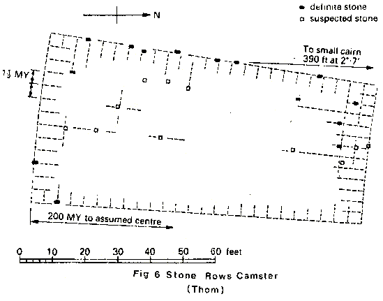
TABLE 3
|
Row |
1 |
2 |
3 |
4 |
5 |
6 |
|
Stones |
11 |
9 |
5 |
4 |
3 |
2 |
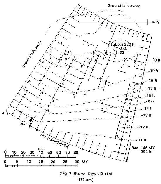
| 10. Dirlot ND123485 About 100m north west of the Thurso river and situated on the slope of a small hill is the setting of stone rows at Dirlot. The site is presently much overgrown with heather and the stones are difficult to locate. About 14 rows may be'id1ontified with the narrow end of the fan continuing just over the top of the hill.Most of the stones are small with only about 15cm showing above the surface although at the wide end of the fan some stones are larger and up to 60om high. They are all of local stone set pointing along the rows.On top of the hill are two small mounds which may be cairns. The setting of the rows bears a number of similarities with Mid Clyth although there appears to be only a single fan. Also the centre of the sector is beyond the top of the hill which puts it out of sight from most of the stones.A plan of the survey made by Professor Thom and given in Thom (1971, 96) is reproduced in Figure 7. Here the main axis is seen to lie approximately ESE and WNW.
Acknowledgements The authors gratefully acknowledge permission given to reproduce the following diagrams: |
R E F E R E N C E S
|
Anderson J. |
Scotland in pagan times II |
Edinburgh |
1886 |
|
Atkinson R.J.C. |
Appendix to Ruggles, C.L.N. |
1981 | |
|
Burl, H.A.W. |
The Stone Circles of the British Isles |
Yale University Press |
1976 |
|
Hadingham, E. |
Circles and Standing Stones |
Heinemann,London |
1975 |
|
Myatt, L.J. |
The Multiple Stone Rows of Caithness and Sutherland I |
C.F.C.Bull.1980 Vol. 2, No.7, 191-195 |
1980 |
|
Ruggles C.L.N. |
A Critical Examination of the Megalithic Lunar Observatories in Ruggles C.L.N. and Whittle A.W.R. (eds.) Megalithic Astronomy and Society |
Brit. Archaeol. Rep., Oxford |
1981 |
|
Thom. A. |
The larger unit of length of Megalithic Man |
Jl. R. Statist. Soc. A. |
1964 |
|
Thom. A. |
Megalithic sites in Britain |
Oxford University Press |
1967 |
|
Thom. A. |
Megalithic lunar observatories |
Oxford University Press |
1971 |
Published in April 1982 Bulletin


