| Introduction | The Castles | Images | Links | History Of Caithness | Glossary | A to Z of Caithness |
• Reconstruction Paintings • Ground Plans • Area Plans • Photo Galleries • Non-Caithness Castles Paintings |
| Dirlot Castle, Caithness Map Ref: ND 126 486 Landranger Sheet 11 Dirlot Castle Photo Gallery Introduction
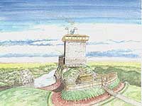
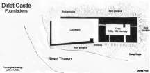
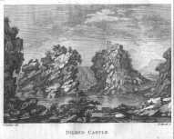
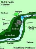
Once you’ve clambered down the slope to the base of the rock and then climbed to the top of it you will no doubt appreciate the practical and enterprising nature of the medieval castle designers and builders as you ponder the sheer logistics of building a stone tower some 50 - 60 ft high on top of such a feature with only manual labour; a formidable task indeed, and yet the structure was used for some 300 years, with some fascinating events taking place there during this period. (More about this later). The keep was very small, measuring only 18ft x 10ft internally with walls 6 ½ ft thick occupying the North end of the Rock, while a courtyard measuring 40ft x 24ft within barmkin walls stood on the South portion into which was an entrance gate on the river side. The keep rose to three storeys in height. The artistic reconstruction by Andrew Spratt shows how the castle may have looked in its prime. Note the defensive hoarding, which allowed defenders to drop material upon attackers at the base of the keep. Access to the keep would be at first floor level from within the courtyard and access to the courtyard gate would be a hazardous journey for attackers around the narrow base of the keep, which was effectively protected from the hoarding above. Tradition states that a wet ditch surrounded the whole. There is a rampart to the West of the base of the rock, about 30 ft out whose purpose has not yet been determined. This still stands to a height of 6ft today. Dirlot has been variously spelt as Dilred, Dildred, Dilraid, Dirlet, Dylrid, Dirlot and Dilryd throughout its history. The true origin of the name is not clear, but it may be derived from the old Scottish word “Dildermot” meaning “an obstacle” or “great difficulty” as indeed it must have been in its day. From the top of the rock it is possible to see Morven, Smean and Maiden Pap some 20 miles distant. So it must have been a dominant structure in its day, noticable from miles around in that flat featureless landscape - a visible and potent symbol of power and authority. The Cheynes, Gunns, Mackays and the Sutherlands occupied the castle at various times until its abandonment around 1660 and like so many of these fine old structures the stone was used elsewhere. In the case of Dirlot, no doubt it was used to construct the walls of the graveyard whose earliest recorded grave is 1664. It is perhaps fitting that the walls were laid out in the shape of an arrowhead, given Dirlot’s long history and true purpose. References:
Also See: |